

| Mesoscale Discussion 2031 | |
| < Previous MD | |
|
|
   Mesoscale Discussion 2031
   NWS Storm Prediction Center Norman OK
   0746 PM CDT Tue Aug 18 2026

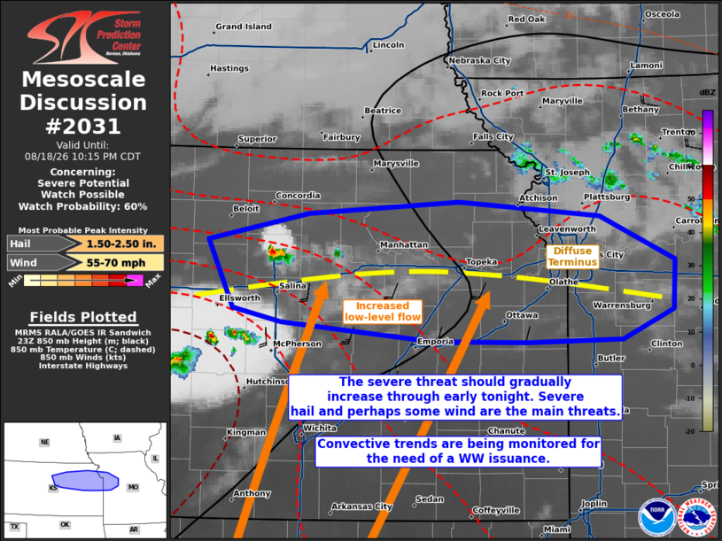
   Areas affected...portions of northern and northeastern Kansas into
   western Missouri

   Concerning...Severe potential...Watch possible

   Valid 190046Z - 190315Z

   Probability of Watch Issuance...60 percent

   SUMMARY...Thunderstorms should increase through the evening and
   early overnight hours, accompanied by a risk of severe hail and
   perhaps a few severe gusts. If convective trends continue to
   indicate an increase in storm coverage, a WW issuance may be needed.

   DISCUSSION...Isolated thunderstorms are attempting to develop ahead
   of a surface low, at the terminus region of a geostrophic low-level
   flow regime. Here, 850 mb frontogenesis/convergence and warm-air
   advection are maximized, likely resulting the intensifying storms.
   Though the 00Z mesoanalysis depicts appreciable MLCINH over
   northeast KS into western MO, isentropic lift should support the
   increase in elevated convection above the inhibition layer, where
   storms may take advantage of available instability (e.g. 7.5-9 C/km
   mid-level lapse rates per 00Z regional observed soundings). 3000
   J/kg MLCAPE amid 50 kts of effective bulk shear will support a mix
   of multicells and supercells tonight, with severe hail and wind the
   main threats. An instance or two of 2+ inch hail cannot be ruled
   out. A WW issuance may be needed pending favorable trends in greater
   storm coverage.

   ..Squitieri/Gleason.. 08/19/2026

   ...Please see www.spc.noaa.gov for graphic product...

   ATTN...WFO...EAX...TOP...ICT...GID...

   LAT...LON   39259832 39489729 39579572 39459427 39109349 38709350
               38469404 38449501 38459598 38539681 38609756 38709806
               39259832

   MOST PROBABLE PEAK WIND GUST...55-70 MPH
   MOST PROBABLE PEAK HAIL SIZE...1.50-2.50 IN
|
|
|
Top/All Mesoscale Discussions/Forecast Products/Home |
|
Source link