

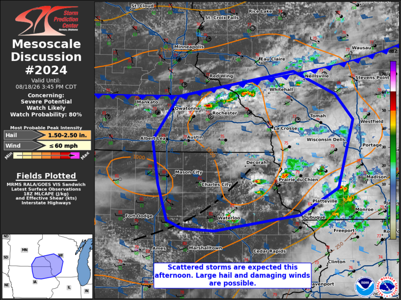
| Mesoscale Discussion 2024 | |
| < Previous MD | |

|
|
   Mesoscale Discussion 2024
   NWS Storm Prediction Center Norman OK
   0152 PM CDT Tue Aug 18 2026

   Areas affected...Northern Iowa into southeast Minnesota and
   southwestern Wisconsin

   Concerning...Severe potential...Watch likely

   Valid 181852Z - 182045Z

   Probability of Watch Issuance...80 percent

   SUMMARY...Large hail (some around 2 in.) and damaging winds will be
   possible with scattered storms in the Upper Midwest. A watch is
   likely this afternoon.

   DISCUSSION...A weak MCV and associated cloud cover is present within
   much of central/southern Wisconsin this afternoon. That said, strong
   heating is occurring near a surface trough in northeast Iowa.
   Thunderstorms have recently developed but have thus far not been
   able to mature. Continued destabilization into southwestern
   Wisconsin may allow this activity to pose an increasing severe
   threat over the next couple of hours. Convective coverage is also
   expected to increase along the cold front, though this may be
   delayed until later this afternoon given the cloud cover. Moderately
   strong mid-level winds on the southern flank of the upper-level low
   is supporting around 40-45 kt of effective shear. Hodographs are
   long and straight which suggests splitting supercells. Large hail
   (with hail to around 2 inches possible, particularly in the
   westernmost areas where mid-level lapse rates are steeper) and
   damaging winds will be possible this afternoon.

   ..Wendt/Guyer.. 08/18/2026

   ...Please see www.spc.noaa.gov for graphic product...

   ATTN...WFO...GRB...MKX...DVN...ARX...MPX...DMX...

   LAT...LON   42579070 42349238 42389302 42499334 43029352 43669364
               44319313 44689080 44338997 43978961 42968992 42579070

   MOST PROBABLE PEAK WIND GUST...UP TO 60 MPH
   MOST PROBABLE PEAK HAIL SIZE...1.50-2.50 IN
|
|
|
Top/All Mesoscale Discussions/Forecast Products/Home |
|
Source link