

| Mesoscale Discussion 2021 | |
| < Previous MD | |

|
|
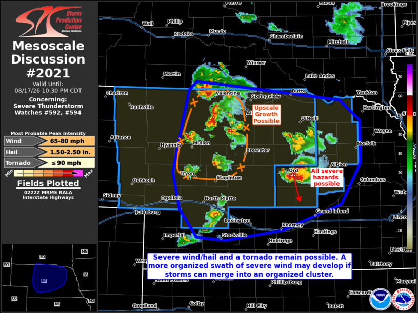
Mesoscale Discussion 2021 NWS Storm Prediction Center Norman OK 0925 PM CDT Mon Aug 17 2026 Areas affected...portions of central into northern Nebraska Concerning...Severe Thunderstorm Watch 592...594... Valid 180225Z - 180330Z The severe weather threat for Severe Thunderstorm Watch 592, 594 continues. SUMMARY...Severe gusts/hail remains possible with supercell structures, and a tornado may still occur with an intense supercell over Valley County. If storms in northern Nebraska can grow upscale into an MCS, an organized wind swath may occur. DISCUSSION...Multiple supercells continue to progress across central and northern NE with a history of severe gusts and occasional large hail. An intense right-moving supercell over Valley County, NE has also demonstrated periods of low-level rotation and remains capable of producing a tornado. In the immediate term, severe wind and hail (some significant) remains possible with any mature supercell structure given 3000+ J/kg MLCAPE and over 40 kts of effective bulk shear in place. KLNX radar trends show several supercell structures and accompanying outflow boundaries merging over central and northern NE. This is where several of the latest HRRR runs have also depicted upscale growth into a cold-pool-driven MCS. If this trend continues, an organized swath of strong to severe gusts may manifest over central into eastern NE over the next few hours. However, MLCINH will continue to increase through the evening. The current thinking is that storms that fail to grow upscale over the next few hours may begin to diminish with boundary-layer decoupling. ..Squitieri.. 08/18/2026 ...Please see www.spc.noaa.gov for graphic product... ATTN...WFO...FSD...OAX...GID...LBF...UNR... LAT...LON 41620144 42470125 42970111 43120095 43080042 42819775 42479732 41789732 41089775 40669905 40490028 40550091 41000128 41620144 MOST PROBABLE PEAK TORNADO INTENSITY...UP TO 90 MPH MOST PROBABLE PEAK WIND GUST...65-80 MPH MOST PROBABLE PEAK HAIL SIZE...1.50-2.50 IN |
|
|
Top/All Mesoscale Discussions/Forecast Products/Home |
|
Source link