

| Mesoscale Discussion 2020 | |
| < Previous MD | |

|
|
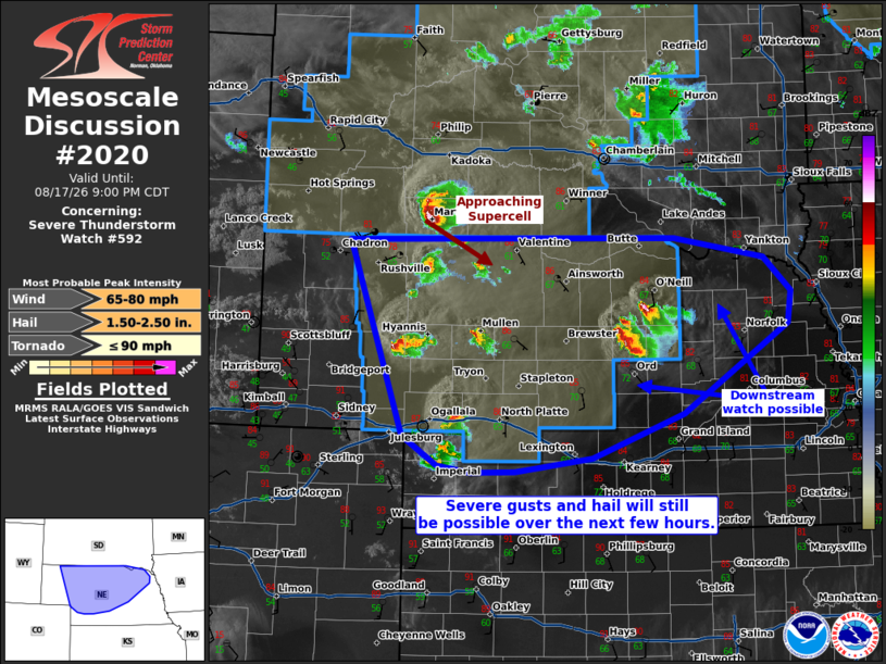
Mesoscale Discussion 2020 NWS Storm Prediction Center Norman OK 0802 PM CDT Mon Aug 17 2026 Areas affected...much of central and northern Nebraska Concerning...Severe Thunderstorm Watch 592... Valid 180102Z - 180200Z The severe weather threat for Severe Thunderstorm Watch 592 continues. SUMMARY...Severe wind gusts and hail should continue to accompany ongoing supercells for at least a few more hours. Some supercells may exit the eastern bounds of Severe Thunderstorm Watch 592. DISCUSSION...Multiple supercells are in progress across much of central and northern NE, with a severe-wind producing supercell also poised to cross into Cherry County, NE from SD. The 00Z LBF observed sounding showed minimal capping in place, with near 8 C/km mid-level lapse rates overspreading a well-mixed boundary layer amid an elongated straight hodograph (and 30+ kts of effective bulk shear). These conditions will support continued severe wind/hail potential for at least a few more hours, until boundary layer stabilization sets in. An instance of 2+ inch diameter hail or a 75+ mph gust cannot be ruled out. Some of the latest HRRR runs also depict upscale growth into an MCS in central NE. However, confidence in this scenario remains uncertain given the resistance of storms to grow upscale thus far. Some of the supercells in central NE are splitting and approaching counties outside of the ongoing Severe Thunderstorm Watch. A WW issuance may be needed farther to the east if confidence increases in a longer-term severe threat for eastern NE. ..Squitieri/Gleason.. 08/18/2026 ...Please see www.spc.noaa.gov for graphic product... ATTN...WFO...FSD...OAX...GID...LBF...BOU...CYS... LAT...LON 42940283 42989835 42769713 42419676 42099681 41179824 40729950 40590054 40570116 40640160 40950208 42940283 MOST PROBABLE PEAK TORNADO INTENSITY...UP TO 90 MPH MOST PROBABLE PEAK WIND GUST...65-80 MPH MOST PROBABLE PEAK HAIL SIZE...1.50-2.50 IN |
|
|
Top/All Mesoscale Discussions/Forecast Products/Home |
|
Source link