

| Mesoscale Discussion 2019 | |
| < Previous MD Next MD > | |
|
|
   Mesoscale Discussion 2019
   NWS Storm Prediction Center Norman OK
   0716 PM CDT Mon Aug 17 2026

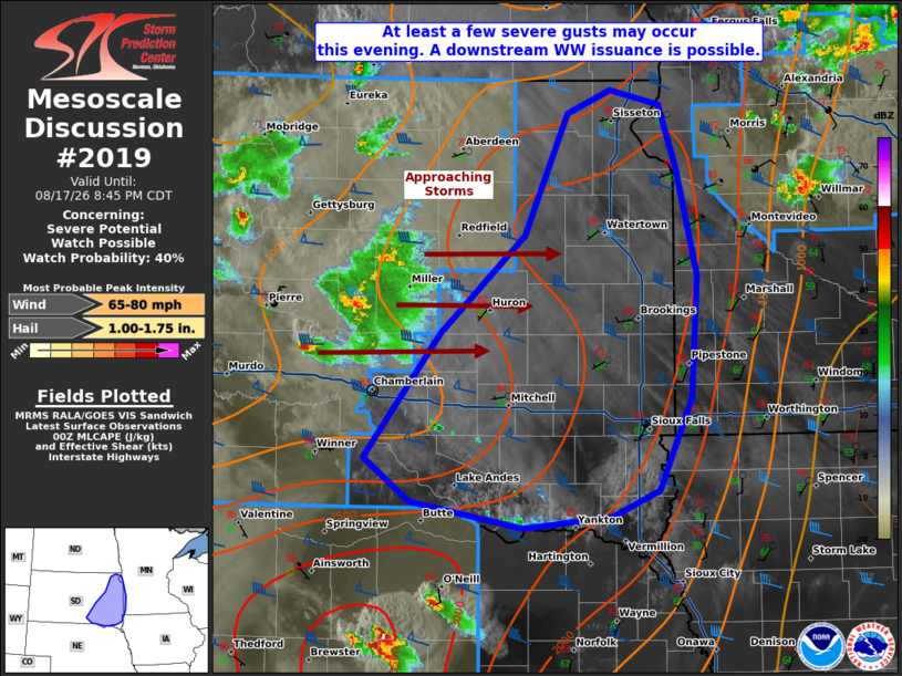
   Areas affected...portions of eastern South Dakota

   Concerning...Severe potential...Watch possible

   Valid 180016Z - 180145Z

   Probability of Watch Issuance...40 percent

   SUMMARY...At least a few severe gusts may occur with the stronger
   storms that manage to intensify and become sustained. A WW issuance
   is possible pending favorable intensification trends.

   DISCUSSION...Scattered supercells and multicells continue to track
   across central SD with a history of producing measured severe gusts.
   MRMS mosaic radar trends suggest that some weakening of the ongoing
   storms has taken place over the past hour or so, casting some
   uncertainty to the long-term severe potential. Nonetheless, these
   storms are preceded by a favorable thermodynamic and kinematic
   environment. The 00Z ABR observed sounding depicted a buoyant
   airmass and no MLCINH, with nearly 2000 J/kg MLCAPE amid an
   elongated hodograph with over 30 kts of effective bulk shear. The
   00Z mesoanalysis also depicted similar conditions present across
   most of eastern SD. Such conditions would support a continued severe
   gust threat into the evening hours. As such, convective trends will
   continue to be monitored for the possibility of a Severe
   Thunderstorm Watch issuance.

   ..Squitieri/Gleason.. 08/18/2026

   ...Please see www.spc.noaa.gov for graphic product...

   ATTN...WFO...MPX...FSD...ABR...LBF...

   LAT...LON   43129660 42939704 42869789 43039896 43349940 44209867
               44879787 45709747 45879706 45769658 45359643 44609622
               43769628 43129660

   MOST PROBABLE PEAK WIND GUST...65-80 MPH
   MOST PROBABLE PEAK HAIL SIZE...1.00-1.75 IN
|
|
|
Top/All Mesoscale Discussions/Forecast Products/Home |
|
Source link