

| Mesoscale Discussion 2016 | |
| < Previous MD | |
|
|
   Mesoscale Discussion 2016
   NWS Storm Prediction Center Norman OK
   0529 PM CDT Mon Aug 17 2026

   Areas affected...portions of western into central Nebraska

   Concerning...Severe potential...Watch likely

   Valid 172229Z - 172330Z

   Probability of Watch Issuance...80 percent

   SUMMARY...The risk for severe hail and wind is increasing across
   portions of western and central Nebraska. A WW issuance will be
   issued soon.

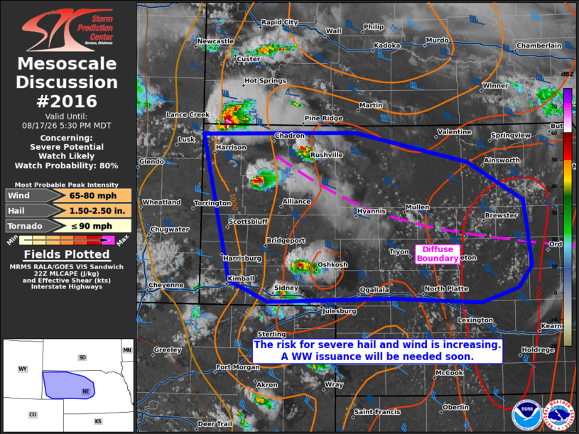
   DISCUSSION...A mature supercell is approaching NE from extreme
   southwestern SD, with additional storms developing along the higher
   terrain along the NE/CO border. The storms in far northwestern NE
   are traversing a diffuse baroclinic boundary, where relatively
   richer moisture (i.e. mid 60s F surface dewpoints) is in place. 22Z
   mesoanalysis also depicts 7.5-8 C/km mid-level lapse rates
   overspreading this moisture, yielding 2500+ J/kg MLCAPE.
   Furthermore, a 500 mb mid-level impulse is glancing the region to
   the north, encouraging modest upper support and 45 kts of effective
   bulk shear. The current thinking is that supercell development may
   continue across western and central NE this evening.

   Storms closer to the NE/CO border are overspreading a drier, mixed
   boundary layer, casting some uncertainty to their longevity given
   weaker forcing farther south. However, the storms traversing the
   aforementioned boundary/richer moisture will have the best chance at
   maintaining intensity and producing severe gusts as well as large
   hail (a stone or two of which could exceed 2 inches in diameter). A
   Severe Thunderstorm Watch is likely given increasing storm coverage
   and intensity.

   ..Squitieri/Gleason.. 08/17/2026

   ...Please see www.spc.noaa.gov for graphic product...

   ATTN...WFO...GID...LBF...CYS...

   LAT...LON   42890403 42910176 42580009 42159926 41429916 41199935
               41039990 41070124 41040305 41260363 42890403

   MOST PROBABLE PEAK TORNADO INTENSITY...UP TO 90 MPH
   MOST PROBABLE PEAK WIND GUST...65-80 MPH
   MOST PROBABLE PEAK HAIL SIZE...1.50-2.50 IN
|
|
|
Top/All Mesoscale Discussions/Forecast Products/Home |
|
Source link