

| Mesoscale Discussion 2005 | |
| < Previous MD | |

|
|
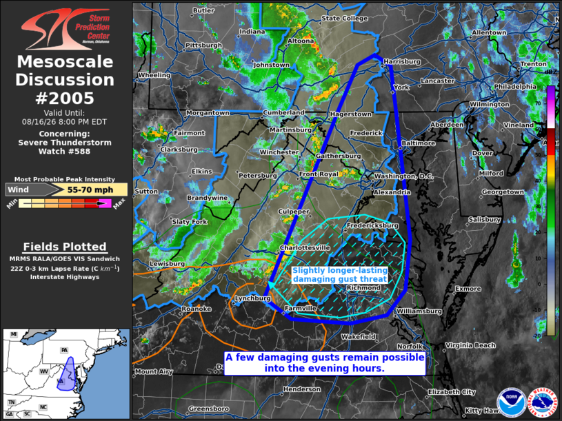
Mesoscale Discussion 2005 NWS Storm Prediction Center Norman OK 0600 PM CDT Sun Aug 16 2026 Areas affected...portions of far south-central Pennsylvania into Maryland...D.C....and northern and central Virginia Concerning...Severe Thunderstorm Watch 588... Valid 162300Z - 170000Z The severe weather threat for Severe Thunderstorm Watch 588 continues. SUMMARY...A few damaging gusts may occur with ongoing storms over the next few hours. The severe threat should remain relatively more isolated. DISCUSSION...A loosely organized cold-pool-driven MCS, with a history of numerous damaging gusts, is cresting the Blue Ridge Mountains and is poised to approach the Chesapeake Bay over the next few hours. Surface temperatures remain in the 80s F, with low-level lapse rates still around 7 C/km per 22Z mesoanalysis. Nonetheless, nocturnal cooling will begin soon along the East Coast, which will further reduce instability. In the near-term a few damaging gusts remain possible with storms along the leading edge of a cold pool. The best chance for a damaging or even severe gust will be with storms propagating toward central VA, where boundary-layer instability is strongest. ..Squitieri.. 08/16/2026 ...Please see www.spc.noaa.gov for graphic product... ATTN...WFO...AKQ...CTP...LWX...RNK... LAT...LON 37487868 39777754 40287726 40407699 40277675 39727666 39057657 38187646 37577654 37277683 37187737 37237826 37487868 MOST PROBABLE PEAK WIND GUST...55-70 MPH |
|
|
Top/All Mesoscale Discussions/Forecast Products/Home |
|
Source link