

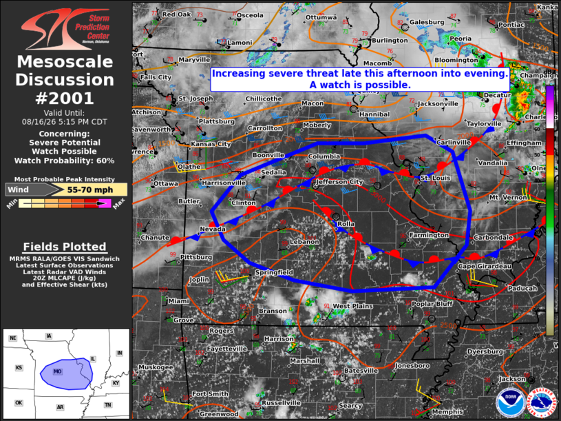
| Mesoscale Discussion 2001 | |
| < Previous MD | |

|
|
   Mesoscale Discussion 2001
   NWS Storm Prediction Center Norman OK
   0311 PM CDT Sun Aug 16 2026

   Areas affected...central and southern Missouri into southwest
   Illinois

   Concerning...Severe potential...Watch possible

   Valid 162011Z - 162215Z

   Probability of Watch Issuance...60 percent

   SUMMARY...The threat for severe storms capable of mainly damaging
   wind gusts is expected to increase across the area late this
   afternoon into evening. A severe thunderstorm watch is possible.

   DISCUSSION...Visible satellite and surface observations indicate a
   couple of boundaries remnant from earlier storms located over the
   region as of 20Z. Objective analysis shows, and visible satellite
   confirms residual capping over northeast and east-central MO into
   adjacent west-central and southwest IL. To the south of those areas
   over central and southern MO, temperatures have warmed to around 100
   F with considerably more boundary-layer-based cumulus development,
   coincident with an uncapped environment with MLCAPE of 2000-3000
   J/kg. That area resides to the south of the stronger forcing for
   ascent and associated, stronger mid-level flow related to an MCV
   moving along the IA-MO border.

   Variability exists across the latest CAM guidance and time-lagged
   ensembles in specific details regarding the preferred location(s)
   for storm development later this afternoon. In general, there is a
   signal for eventual upscale growth of initial more discrete storms
   into an MCS, which tracks into southern IL this evening. Given the
   presence of a hot, well-mixed boundary layer already in place across
   central and southern MO, the setup appears favorable for at least
   isolated damaging wind gusts with the most intense storms. A more
   concentrated area of damaging wind potential may materialize this
   evening should storms merge into an MCS along a coalescing cold
   pool. Convective trends are being monitored for a possible watch
   issuance.

   ..Mead/Guyer.. 08/16/2026

   ...Please see www.spc.noaa.gov for graphic product...

   ATTN...WFO...PAH...LSX...SGF...EAX...

   LAT...LON   37769388 38189411 38729359 39219213 39219124 39339005
               39088955 38198923 37698931 37078993 37019147 37179255
               37429339 37769388

   MOST PROBABLE PEAK WIND GUST...55-70 MPH
|
|
|
Top/All Mesoscale Discussions/Forecast Products/Home |
|
Source link