

| Mesoscale Discussion 1992 | |
| < Previous MD | |

|
|
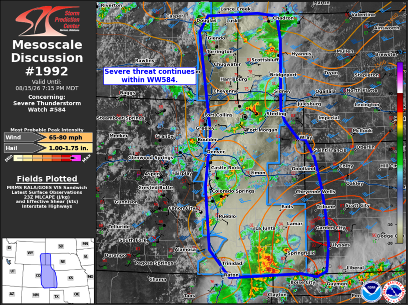
Mesoscale Discussion 1992 NWS Storm Prediction Center Norman OK 0608 PM CDT Sat Aug 15 2026 Areas affected...eastern Colorado/Wyoming into western Kansas Concerning...Severe Thunderstorm Watch 584... Valid 152308Z - 160115Z The severe weather threat for Severe Thunderstorm Watch 584 continues. SUMMARY...Severe threat continues within WW584. DISCUSSION...Several clusters of storms and a few more isolated supercells continue within WW584. A supercell near Denver had reports of 64 mph winds and hail up to 1.75 inches in diameter. Large hail and damaging wind will continue to be possible with supercells through the early evening, given moderate instability and 35-45 kts of effective shear. With cell interactions, mode is gradually shifting to become more clustered/multi-cell this evening. Guidance suggests that one or more clusters may evolve eastward into western Kansas through the evening. Downstream across western Kansas, steep low to mid-level lapse rates, temperatures in the mid 80s to low 90s F, and dew points in the upper 60s to 70s are supporting moderate to strong instability, though lingering inhibition remains. Should a cluster be able to organize along a cold pool and shift eastward, damaging wind potential may increase into the evening. A downstream watch will probably be needed into western Kansas later this evening. ..Thornton/Gleason.. 08/15/2026 ...Please see www.spc.noaa.gov for graphic product... ATTN...WFO...LBF...DDC...UNR...GLD...AMA...PUB...BOU...CYS... ABQ... LAT...LON 36910425 37550483 39000497 40280485 42560523 42940498 42990396 43020344 42950284 42410274 40780274 40530261 40120222 40100201 39680174 38940154 38330145 37650138 37050146 36920174 37010218 36950353 36910425 MOST PROBABLE PEAK WIND GUST...65-80 MPH MOST PROBABLE PEAK HAIL SIZE...1.00-1.75 IN |
|
|
Top/All Mesoscale Discussions/Forecast Products/Home |
|
Source link