

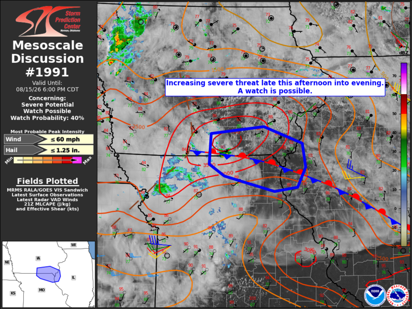
| Mesoscale Discussion 1991 | |
| < Previous MD | |

|
|
   Mesoscale Discussion 1991
   NWS Storm Prediction Center Norman OK
   0402 PM CDT Sat Aug 15 2026

   Areas affected...south-central and southeast IA...north-central and
   northeast Missouri...and west-central Illinois

   Concerning...Severe potential...Watch possible

   Valid 152102Z - 152300Z

   Probability of Watch Issuance...40 percent

   SUMMARY...The threat for at least isolated severe weather may
   increase across the area late this afternoon into evening.
   Convective trends are being monitored for a possible watch.

   DISCUSSION...A thunderstorm has recently developed along the IA-MO
   border, near Centerville, IA along a residual outflow boundary that
   extends into west-central IL. A very moist boundary-layer exists in
   the vicinity of the surface front with dewpoints into the mid 70s to
   lower 80s, which are contributing to MLCAPE of 3000-3500+ J/kg, per
   latest objective analysis. Forcing associated with a remnant MCV may
   be contributing to the storm development with the current EAX VWP
   indicating 30-35 kt of westerly flow in the mid levels, suggestive
   of at least modest vertical shear. As such, some potential for
   isolated severe weather appears to exist, mainly in the form of
   locally damaging wind gusts, should sustained storms persist late
   this afternoon into evening.

   ..Mead/Guyer.. 08/15/2026

   ...Please see www.spc.noaa.gov for graphic product...

   ATTN...WFO...ILX...LSX...DVN...DMX...EAX...

   LAT...LON   40419332 41019328 41159192 40829093 40359086 39969106
               39899165 40189293 40419332

   MOST PROBABLE PEAK WIND GUST...UP TO 60 MPH
   MOST PROBABLE PEAK HAIL SIZE...UP TO 1.25 IN
|
|
|
Top/All Mesoscale Discussions/Forecast Products/Home |
|
Source link