

| Mesoscale Discussion 1989 | |
| < Previous MD Next MD > | |
|
|
   Mesoscale Discussion 1989
   NWS Storm Prediction Center Norman OK
   0325 PM CDT Sat Aug 15 2026

   Areas affected...Far northeast New Mexico...the Oklahoma
   Panhandle...and southwest Kansas

   Concerning...Severe potential...Watch possible

   Valid 152025Z - 152300Z

   Probability of Watch Issuance...60 percent

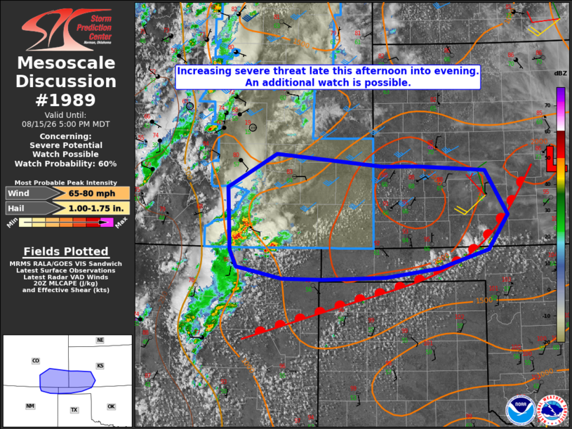
   SUMMARY...The threat for severe storms capable of mainly severe wind
   gusts, potentially up to 70-80 mph, is expected to increase across
   the discussion area late this afternoon into evening. An additional
   watch is possible to the east/southeast of the recently issued
   severe thunderstorm watch 584 in effect across southeast Colorado.

   DISCUSSION...Thunderstorms have developed along the Sangre de Cristo
   Mountains and adjacent Raton Mesa with a deepening cumulus field
   noted along a warm front from southwest KS into the OK and TX
   Panhandles. The 18Z DDC and AMA soundings modified for current
   surface conditions exhibit steep environmental lapse rates
   (especially in the low levels) with MLCAPE of 1500-2500 J/kg.
   Continued daytime heating should allow for further air mass
   destabilization with the strongest instability forecast north of the
   front from far southeast CO into southwest KS.

   Latest CAM guidance suggests the storms developing along the Sangre
   de Cristo Mountains will gradually grow upscale into one or multiple
   clusters later this afternoon into evening while moving/developing
   east into the High Plains. The recently issued severe thunderstorm
   watch 584 accounts for the large hail and severe wind gust potential
   with that regime. Additional storms will also be possible along the
   surface boundary from the northern TX into OK Panhandles and
   southwest KS, with some model signal for the separate regimes to
   merge across southwest KS this evening. Severe wind gusts,
   potentially up to 70-80 mph, appear to be the primary hazard with
   the latter regime, and convective trends are being monitored for an
   additional severe thunderstorm watch.

   ..Mead/Guyer.. 08/15/2026

   ...Please see www.spc.noaa.gov for graphic product...

   ATTN...WFO...OUN...DDC...AMA...PUB...ABQ...

   LAT...LON   36960469 37880474 38370384 38200186 38200122 38129996
               37479956 36959991 36690083 36550182 36520296 36530373
               36700457 36960469

   MOST PROBABLE PEAK WIND GUST...65-80 MPH
   MOST PROBABLE PEAK HAIL SIZE...1.00-1.75 IN
|
|
|
Top/All Mesoscale Discussions/Forecast Products/Home |
|
Source link