

| Mesoscale Discussion 1980 | |
| < Previous MD Next MD > | |
|
|
   Mesoscale Discussion 1980
   NWS Storm Prediction Center Norman OK
   0314 PM CDT Fri Aug 14 2026

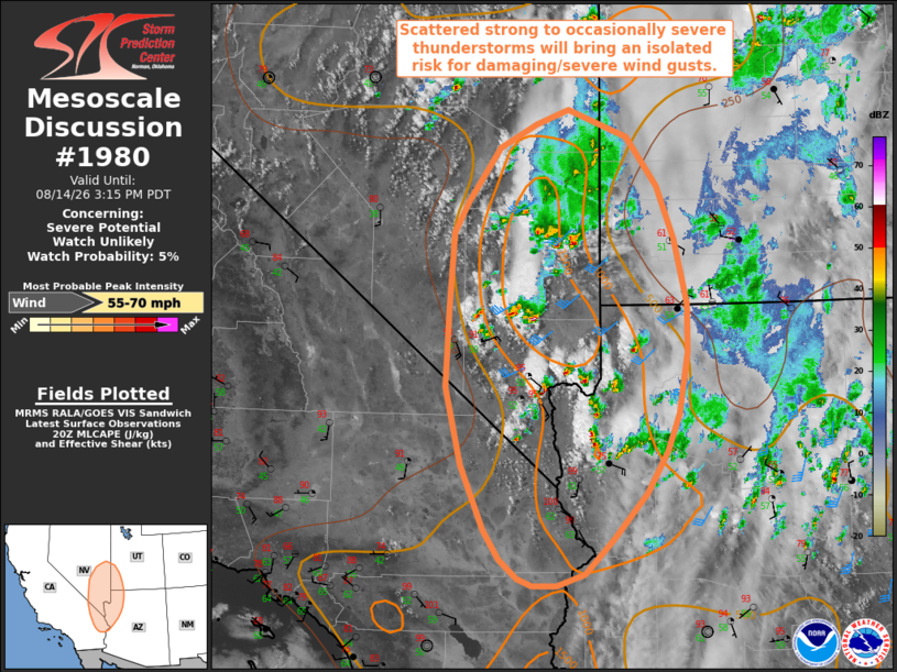
   Areas affected...portions of the southern Great Basin into the lower
   Colorado River Basin

   Concerning...Severe potential...Watch unlikely

   Valid 142014Z - 142215Z

   Probability of Watch Issuance...5 percent

   SUMMARY...Scattered strong to occasionally severe thunderstorms will
   bring an isolated risk for damaging/severe wind gusts through this
   afternoon.

   DISCUSSION...In the wake of morning cloud cover, strong diurnal
   heating and steepening low-level lapse rates amid low-to-mid 50s
   dewpoints are supporting scattered thunderstorm development within a
   corridor of greater buoyancy (500-1500 J/kg MLCAPE) across portions
   of the Great Basin and lower Colorado River Basin. Enhanced
   southwesterly flow downstream of an upper low centered off of the
   California coastline is contributing to modestly enhanced effective
   shear of 25-35 kts, sufficient for modest updraft organization. In
   conjunction with steep low-to-mid level lapse rates, high LCLs (2-3+
   km), and inverted-V thermodynamic profiles, an isolated risk for
   damaging/severe wind gusts may accompany developing thunderstorms
   through this evening. This risk is expected to remain relatively
   isolated. Thus, watch issuance is not anticipated.

   ..Chalmers/Guyer.. 08/14/2026

   ...Please see www.spc.noaa.gov for graphic product...

   ATTN...WFO...FGZ...SLC...PSR...VEF...LKN...

   LAT...LON   38301327 37721304 37011287 36481286 35801298 35391314
               34941342 34451386 34061425 33931463 33921497 34011517
               34221541 34541562 35241593 36101614 36971610 37781603
               38131585 38721542 38981491 39141448 38831367 38301327

   MOST PROBABLE PEAK WIND GUST...55-70 MPH
|
|
|
Top/All Mesoscale Discussions/Forecast Products/Home |
|
Source link