

| Mesoscale Discussion 1960 | |
| < Previous MD | |
|
|
   Mesoscale Discussion 1960
   NWS Storm Prediction Center Norman OK
   0551 PM CDT Wed Aug 12 2026

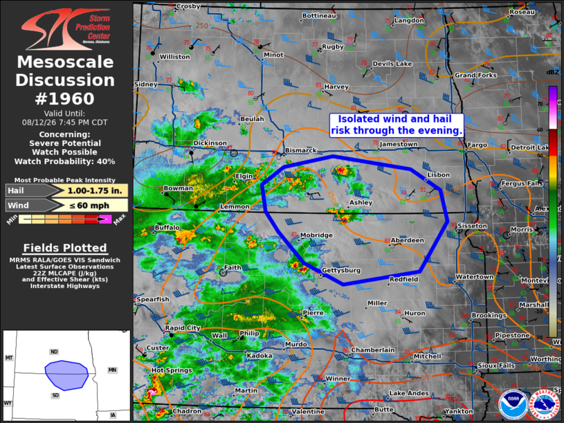
   Areas affected...portions of south-central North Dakota into
   north-central South Dakota

   Concerning...Severe potential...Watch possible

   Valid 122251Z - 130045Z

   Probability of Watch Issuance...40 percent

   SUMMARY...Isolated supercells may pose a threat for large hail and
   damaging wind over the next couple of hours.

   DISCUSSION...Supercells have developed across portions of
   south-central ND into north-central SD over the last hour. These
   will pose a risk for a few isolated instances of large hail and
   damaging wind this evening. These are occurring on the fringes of
   better moisture that is located across central South Dakota into the
   central Plains as large scale ascent overspreads the region. Though
   moisture decreases with northern extent, strong deep layer shear may
   support maintenance of an isolated supercell or two. Given the more
   isolated nature of this threat, watch issuance is not anticipated
   but trends will be monitored.

   ..Thornton/Hart.. 08/12/2026

   ...Please see www.spc.noaa.gov for graphic product...

   ATTN...WFO...FGF...ABR...BIS...

   LAT...LON   45950114 45650087 45190031 44879946 45069783 45809722
               46289736 46599801 46799969 46620077 46350123 45950114

   MOST PROBABLE PEAK WIND GUST...UP TO 60 MPH
   MOST PROBABLE PEAK HAIL SIZE...1.00-1.75 IN
|
|
|
Top/All Mesoscale Discussions/Forecast Products/Home |
|
Source link