

| Mesoscale Discussion 1942 | |
| < Previous MD Next MD > | |

|
|
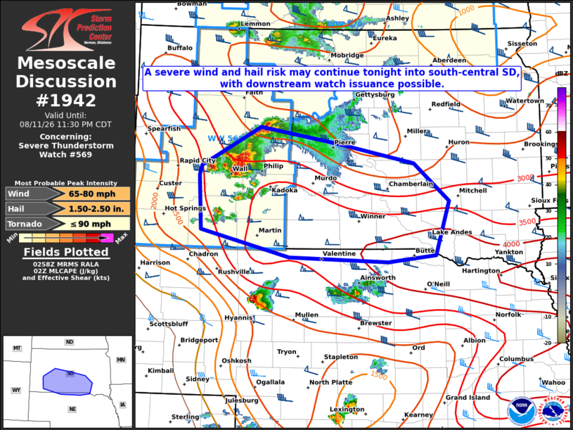
Mesoscale Discussion 1942 NWS Storm Prediction Center Norman OK 1000 PM CDT Tue Aug 11 2026 Areas affected...Parts of western into south-central SD and far northern NE Concerning...Severe Thunderstorm Watch 569... Valid 120300Z - 120430Z The severe weather threat for Severe Thunderstorm Watch 569 continues. SUMMARY...A severe wind and hail risk may continue tonight into south-central South Dakota and vicinity, with downstream watch issuance possible. DISCUSSION...A well established supercell has gradually transitioned into a small bowing complex across western SD over the past hour or two, with mainly measured severe wind gusts up to around 75-80 mph. Even with the onset of nocturnal cooling, a reservoir of rich low-level moisture (with upper 60s to low 70s surface dewpoints) and steep mid-level lapse rates are supporting a narrow corridor of strong instability per latest mesoanalysis estimates. It is plausible that the ongoing small bow will track east-southeastward along the instability axis into south-central SD over the next few hours while continuing to pose a threat for severe gusts and hail. Time-lagged HRRR/RRFS runs support this scenario, with some members showing significant gust potential (75+ mph) persisting with eastward extent. Therefore, downstream watch issuance is being considered for parts of southern SD and far northern NE before the 04Z expiration of Severe Thunderstorm Watch 569. ..Gleason/Mosier.. 08/12/2026 ...Please see www.spc.noaa.gov for graphic product... ATTN...WFO...FSD...ABR...LBF...UNR... LAT...LON 44090277 44620168 44400022 44149883 43639818 42909843 42819932 42880113 43230277 43960281 44090277 MOST PROBABLE PEAK TORNADO INTENSITY...UP TO 90 MPH MOST PROBABLE PEAK WIND GUST...65-80 MPH MOST PROBABLE PEAK HAIL SIZE...1.50-2.50 IN |
|
|
Top/All Mesoscale Discussions/Forecast Products/Home |
|
Source link