

| Mesoscale Discussion 1938 | |
| < Previous MD | |

|
|
   Mesoscale Discussion 1938
   NWS Storm Prediction Center Norman OK
   0654 PM CDT Tue Aug 11 2026

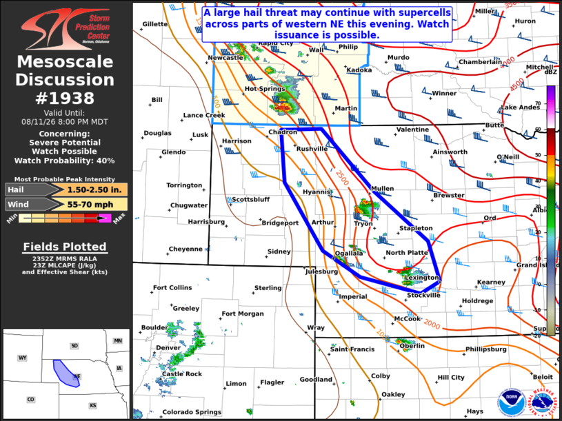
   Areas affected...Parts of the NE Panhandle/western NE

   Concerning...Severe potential...Watch possible

   Valid 112354Z - 120200Z

   Probability of Watch Issuance...40 percent

   SUMMARY...A large hail threat may continue with supercells across
   parts of western Nebraska this evening. Watch issuance is possible.

   DISCUSSION...A long-lived supercell that has a history of producing
   large to very large hail across southwest SD is tracking
   southeastward, and should move into parts of the NE
   Panhandle/western NE in the next hour or so. Other convection is
   also ongoing along and perhaps just east of a weak surface boundary
   draped across western NE. Latest mesoanalysis estimates some
   lingering MLCIN across this region, which is evidenced by updrafts
   struggling to be sustained with southward extent in western NE.
   Still, some risk for large hail may continue with the
   well-established supercell moving southeastward out of southwest SD,
   as deep-layer shear remains strong. Trends are being monitored for
   possible watch issuance, with overall coverage of severe convection
   remaining uncertain.

   ..Gleason/Mosier.. 08/11/2026

   ...Please see www.spc.noaa.gov for graphic product...

   ATTN...WFO...GID...LBF...

   LAT...LON   42930273 42940196 42070095 41359994 40789973 40610009
               40850121 41220191 42180264 42930273

   MOST PROBABLE PEAK WIND GUST...55-70 MPH
   MOST PROBABLE PEAK HAIL SIZE...1.50-2.50 IN
|
|
|
Top/All Mesoscale Discussions/Forecast Products/Home |
|
Source link