

| Mesoscale Discussion 1937 | |
| < Previous MD Next MD > | |

|
|
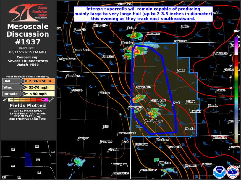
Mesoscale Discussion 1937 NWS Storm Prediction Center Norman OK 0548 PM CDT Tue Aug 11 2026 Areas affected...Parts of western SD Concerning...Severe Thunderstorm Watch 569... Valid 112248Z - 120015Z The severe weather threat for Severe Thunderstorm Watch 569 continues. SUMMARY...Intense supercells will remain capable of producing mainly large to very large hail (up to 2-3.5 inches and diameter) this evening as they track east-southeastward. DISCUSSION...A supercell which developed over the Black Hills earlier this afternoon strengthened and produced large hail up to 3.5 inches in diameter in southwest SD. Since then, additional supercells have developed over far southeast MT into northwest SD, and over the Black Hills. The environment across western SD remains quite favorable for the maintenance for intense supercells this evening, with strong instability and deep-layer shear both present. These supercells are expected to generally track east-southeastward while posing a threat for mainly large to very large hail up to 2.5-3.5 inches in diameter. Some risk for severe/damaging winds will also exist with RFD surges with these intense cells. ..Gleason.. 08/11/2026 ...Please see www.spc.noaa.gov for graphic product... ATTN...WFO...UNR... LAT...LON 45680402 45870388 45830328 45530270 43640213 43130210 43070322 43610392 44120403 45680402 MOST PROBABLE PEAK TORNADO INTENSITY...UP TO 90 MPH MOST PROBABLE PEAK WIND GUST...55-70 MPH MOST PROBABLE PEAK HAIL SIZE...2.00-3.50 IN |
|
|
Top/All Mesoscale Discussions/Forecast Products/Home |
|
Source link