

| Mesoscale Discussion 1934 | |
| < Previous MD | |

|
|
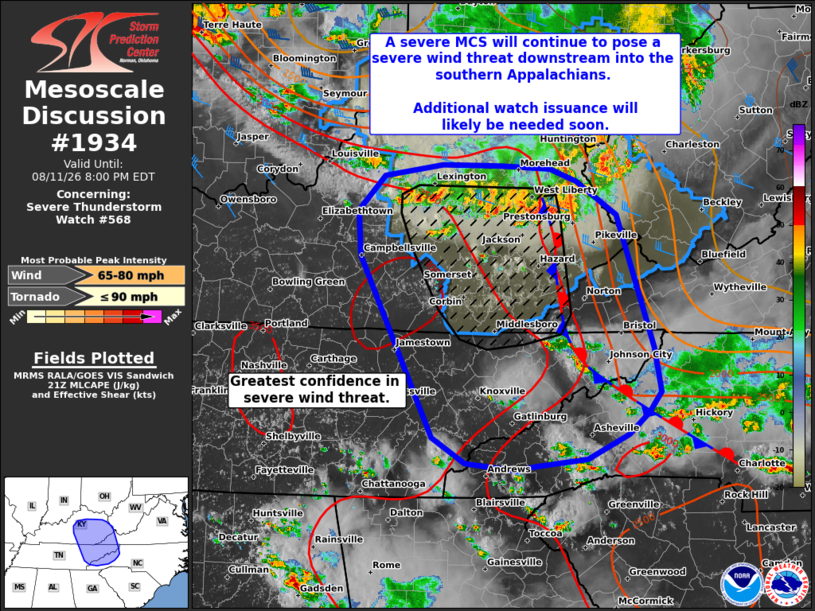
Mesoscale Discussion 1934 NWS Storm Prediction Center Norman OK 0453 PM CDT Tue Aug 11 2026 Areas affected...Eastern Kentucky into northeast Tennessee and adjacent portions of western Virginia and North Carolina Concerning...Severe Thunderstorm Watch 568... Valid 112153Z - 120000Z The severe weather threat for Severe Thunderstorm Watch 568 continues. SUMMARY...A severe MCS will continue to pose a threat for severe winds over the next few hours, and will likely exit the southern edge of WW 568 before a weakening trend occurs. Downstream watch issuance will likely be needed in the next hour or two to address any lingering severe wind threat. DISCUSSION...A severe MCS continues to push south/southeast across northeastern KY with a history of recently producing winds within the line between 55-65 mph based on reports/wind observations. The peak of the bowing segment continues to align with the intersection of the MCS and a residual outflow boundary/frontal zone draped southward from eastern KY into the southern Appalachians. To the west of this boundary, a very buoyant air mass remains in place and will continue to support the potential for intense convection and severe gusts over the next couple of hours as the line approaches the southern edge of WW 568. Beyond roughly 00 UTC, the general expectation is for the MCS to begin weakening with time as it moves into an air mass that has already seen some degree of convective overturning and into a region with weaker deep-layer wind shear. However, given the well-established cold pool and some residual buoyancy, it appears likely that this weakening trend will be gradual with some lingering threat for severe/damaging wind gusts. Additional downstream watch issuance will likely be needed in the next hour or two to address this potential. ..Moore.. 08/11/2026 ...Please see www.spc.noaa.gov for graphic product... ATTN...WFO...RNK...RLX...GSP...MRX...JKL...LMK...OHX... LAT...LON 35258346 35328407 35568447 37348535 37778537 38118505 38228434 38218362 38198304 38078272 37748222 36448179 36008171 35808186 35598209 35358260 35288322 35258346 MOST PROBABLE PEAK TORNADO INTENSITY...UP TO 90 MPH MOST PROBABLE PEAK WIND GUST...65-80 MPH |
|
|
Top/All Mesoscale Discussions/Forecast Products/Home |
|
Source link