

| Mesoscale Discussion 1928 | |
| < Previous MD | |

|
|
   Mesoscale Discussion 1928
   NWS Storm Prediction Center Norman OK
   0140 PM CDT Tue Aug 11 2026

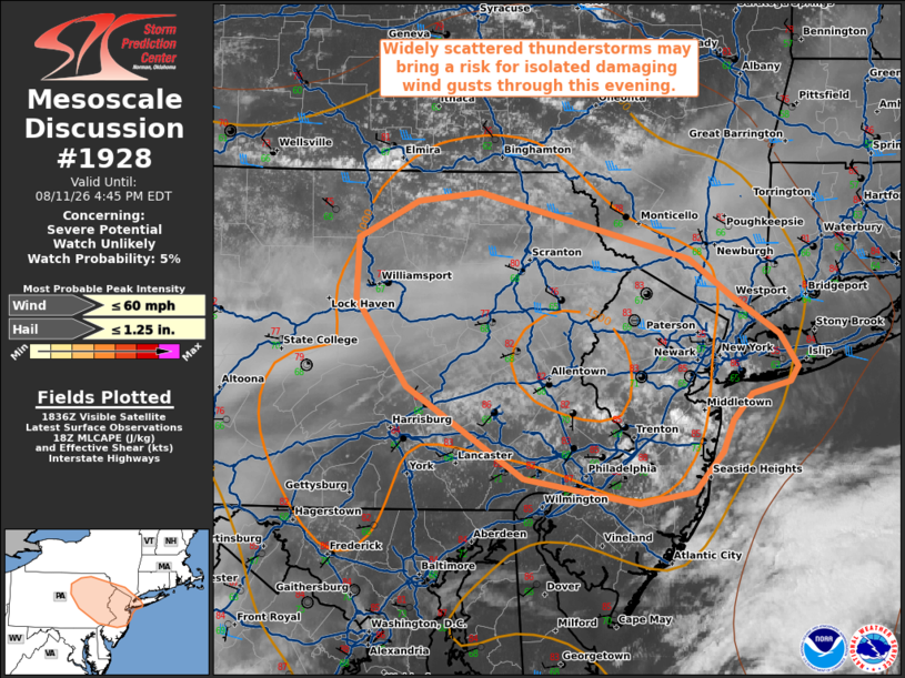
   Areas affected...portions of eastern Pennsylvania into northern New
   Jersey and far southern New York

   Concerning...Severe potential...Watch unlikely

   Valid 111840Z - 112045Z

   Probability of Watch Issuance...5 percent

   SUMMARY...Widely scattered thunderstorm development is expected this
   afternoon from eastern Pennsylvania into northern New Jersey and far
   southern New York. An isolated threat for damaging wind gusts may
   accompany any stronger storms.

   DISCUSSION...Developing/agitated cumulus are noted underneath an
   upper-level cirrus canopy as of 1830 UTC via recent satellite
   imagery. Aided by weak forcing for ascent associated with a subtle
   mid-level perturbation progressing quickly eastward out of southern
   Ontario, continued insolation to the south of a weak surface cold
   front is expected to support isolated to widely scattered
   thunderstorm development over the next 1-3 hours. Effective shear of
   30-35 kts and around 1000-1500 J/kg MLCAPE will promote some
   potential for a few stronger updrafts. Water-loaded downbursts
   capable of isolated damaging wind gusts will be possible with these
   more robust updrafts given modestly steep low-level lapse rates and
   a corridor of locally greater PW (1.5-1.75"). An instance of
   marginally severe hail also cannot be ruled out with any transient
   supercell structure that can develop. Weak mid-level lapse rates
   should largely temper overall convective intensity and severe
   coverage, however. Thus, watch issuance is not anticipated at this
   time.

   ..Chalmers/Hart.. 08/11/2026

   ...Please see www.spc.noaa.gov for graphic product...

   ATTN...WFO...OKX...PHI...BGM...CTP...

   LAT...LON   40117395 40317386 40507368 40577334 40677327 40897343
               41167386 41407423 41857609 41807665 41547717 41137720
               40557674 39937571 39757468 39837419 40117395

   MOST PROBABLE PEAK WIND GUST...UP TO 60 MPH
   MOST PROBABLE PEAK HAIL SIZE...UP TO 1.25 IN
|
|
|
Top/All Mesoscale Discussions/Forecast Products/Home |
|
Source link