

| Mesoscale Discussion 1926 | |
| < Previous MD Next MD > | |

|
|
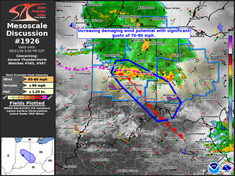
Mesoscale Discussion 1926 NWS Storm Prediction Center Norman OK 1257 PM CDT Tue Aug 11 2026 Areas affected...central into southeast Indiana...southwest Ohio...and potentially into far northern Kentucky Concerning...Severe Thunderstorm Watch 565...567... Valid 111757Z - 112000Z The severe weather threat for Severe Thunderstorm Watch 565, 567 continues. SUMMARY...A corridor of more widespread damaging winds with significant gusts up to 70-80 mph appears to be evolving from central through southeast Indiana into southwest Ohio and far northern Kentucky. An additional downstream watch or watch extension may become necessary. DISCUSSION...Recent KIND base velocity data suggest a strengthening cold pool with ongoing storms over Boone, Hamilton, and Madison Counties, to the north of the Indianapolis metropolitan area. That convection is located near an outflow/warm front composite boundary that has become better defined early this afternoon from central into southeast IN. The air mass to the west of the boundary continues to destabilize with latest objective analysis indicating MLCAPE as high as 3000 J/kg. While low-level lapse rates remain somewhat marginal, continued daytime heating ahead of the ongoing storms should support a steepening trend through the afternoon. The current KIND VWP is sampling largely westerly deep-layer flow with 40-45 kt of deep-layer shear. While the shear vector orientation is not ideally aligned with the ongoing storms as of present, the upstream KLOT VWP suggests that the shear vector may become more favorably oriented with time. When combined with the destabilizing inflow air mass, the setup appears favorable for a corridor of enhanced damaging wind potential focused along or just to the north of the composite boundary. ..Mead.. 08/11/2026 ...Please see www.spc.noaa.gov for graphic product... ATTN...WFO...ILN...IWX...IND... LAT...LON 40228671 40618652 40668601 39938429 39268377 38748414 38658475 39818630 40228671 MOST PROBABLE PEAK TORNADO INTENSITY...UP TO 90 MPH MOST PROBABLE PEAK WIND GUST...65-80 MPH MOST PROBABLE PEAK HAIL SIZE...UP TO 1.25 IN |
|
|
Top/All Mesoscale Discussions/Forecast Products/Home |
|
Source link