

| Mesoscale Discussion 1923 | |
| < Previous MD | |

|
|
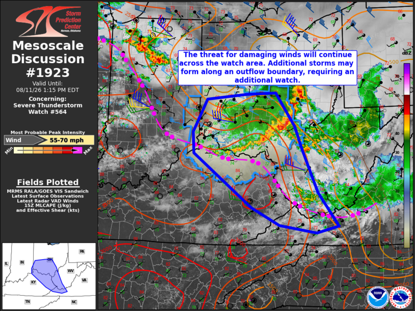
Mesoscale Discussion 1923 NWS Storm Prediction Center Norman OK 1018 AM CDT Tue Aug 11 2026 Areas affected...central Ohio...far southeast Indiana...northeast Kentucky...western West Virginia...and western Virginia Concerning...Severe Thunderstorm Watch 564... Valid 111518Z - 111715Z The severe weather threat for Severe Thunderstorm Watch 564 continues. SUMMARY...The threat for damaging winds is expected to continue across the watch area this morning. Additional storm development is possible along a composite outflow boundary from northeast Kentucky into western Virginia by early afternoon, possibly requiring an additional watch issuance. DISCUSSION...A mature MCS with embedded bowing structure is ongoing as of 1510Z across portions of central and southern OH with a wind gust to 82 mph reported within the past hour at the Columbus John Glenn International Airport. While that portion of the MCS is currently the most intense, considerable downstream convection present from southeast OH into northwest WV leads to uncertainty in the longevity of the damaging wind threat given the convectively overturned air mass. Potentially greater air mass destabilization is expected by early afternoon farther southwest from northeast KY into western portions of WV and VA, in the vicinity of a composite outflow boundary. There, storm intensification on the western flank of the OH MCS appears possible, along with additional in situ development along the boundary. While the region will reside on the southern fringe of stronger vertical shear, the presence of moderate to strong instability with steepening low-level lapse rates will support damaging wind potential with the strongest storms. ..Mead/Hart.. 08/11/2026 ...Please see www.spc.noaa.gov for graphic product... ATTN...WFO...RNK...RLX...MRX...JKL...ILN...LMK... LAT...LON 38698497 39198499 39948458 40068341 40098255 39308200 38798179 37788134 37018076 36858140 37048246 37458328 38698497 MOST PROBABLE PEAK WIND GUST...55-70 MPH |
|
|
Top/All Mesoscale Discussions/Forecast Products/Home |
|
Source link