

| Mesoscale Discussion 1910 | |
| < Previous MD | |

|
|
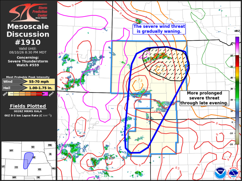
Mesoscale Discussion 1910 NWS Storm Prediction Center Norman OK 0731 PM CDT Mon Aug 10 2026 Areas affected...Western Nebraska into northeast Colorado and northwest Kansas Concerning...Severe Thunderstorm Watch 559... Valid 110031Z - 110230Z The severe weather threat for Severe Thunderstorm Watch 559 continues. SUMMARY...The potential for severe wind gusts is gradually waning across portions of the central High Plains. However, some potential will persist for the next 1-2 hours before the onset of nocturnal cooling. DISCUSSION...Convection has begun to wane across northeast CO and much of the NE Panhandle with the exception of a cluster of storms over Cherry county, NE. This trend is largely due to the prevalence of expanding cold pools across the region with some locations observing temperature falls on the order of 10-15 F within the cold pools. Although some re-development is possible along the edges of the cold pools and/or along colliding outflow boundaries, the spatial extent of the deeply-mixed warm sector is quickly becoming limited. Some severe downburst potential should persist for the next 1-2 hours where outflow propagation and/or convective overturning has not yet occurred, but the onset of nocturnal cooling beyond 02 UTC will act to increase inhibition and further reduce the potential for deep convection. Northeastern portions of WW 559 will likely see a more prolonged severe wind, and perhaps hail, threat heading into the late evening hours where deep convection continues to mature on the western periphery of a more moist and strongly sheared air mass. ..Moore.. 08/11/2026 ...Please see www.spc.noaa.gov for graphic product... ATTN...WFO...LBF...GLD...BOU...CYS... LAT...LON 42740184 42760119 42570027 42060009 41700021 38940217 38740256 38730304 38900325 39480331 41410311 42110301 42510277 42710222 42740184 MOST PROBABLE PEAK WIND GUST...55-70 MPH MOST PROBABLE PEAK HAIL SIZE...1.00-1.75 IN |
|
|
Top/All Mesoscale Discussions/Forecast Products/Home |
|
Source link