

| Mesoscale Discussion 1908 | |
| < Previous MD | |

|
|
   Mesoscale Discussion 1908
   NWS Storm Prediction Center Norman OK
   0615 PM CDT Mon Aug 10 2026

   Areas affected...Far southeast Montana into far southern North
   Dakota and northern South Dakota

   Concerning...Severe potential...Watch possible

   Valid 102315Z - 110115Z

   Probability of Watch Issuance...40 percent

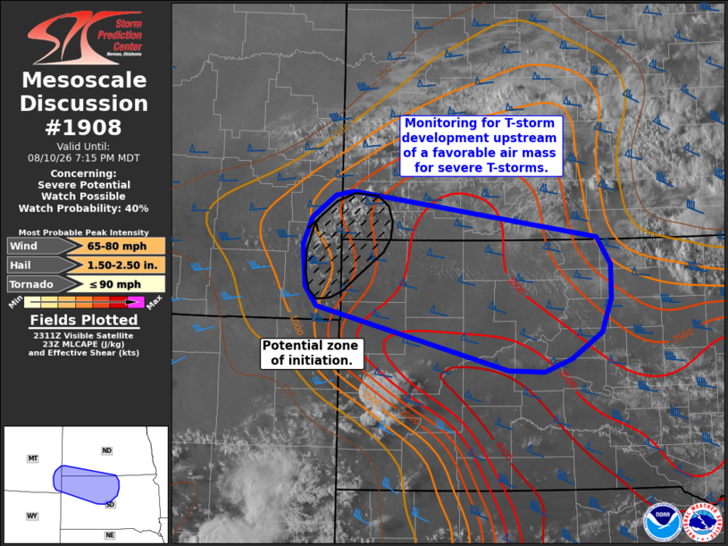
   SUMMARY...Satellite trends are being monitored for thunderstorm
   development across southeast Montana. If thunderstorms can develop
   they will likely move into an air mass very favorable for severe
   convection. Watch issuance is possible if this can occur.

   DISCUSSION...Latest GOES imagery depicts a growing cumulus field
   across southeast Montana in proximity to a weak surface
   low/confluence zone. Although broad-scale forcing for ascent across
   this region is weaker compared to areas further south, the nearby
   thermodynamic environment appears supportive of thunderstorms with
   limited capping and around 2500 J/kg MLCAPE. It remains uncertain
   whether or not ascent across this region will be sufficient to
   initiate and maintain deep convection, and recent guidance shows
   considerable uncertainty on whether or not storms will develop
   (though a few RRFS solutions do hint at this potential).

   However, if convection can develop and be sustained, it will likely
   migrate east/southeast into an increasingly moist air mass where
   MLCAPE values increase to around 3000-4000 J/kg. Additionally, the
   KBIS VWP continues to sample 50-55 knot 0-6 km BWD, which will favor
   organized convection. Storm mode would likely transition from
   semi-discrete cells into an organized cluster/MCS given the
   relatively dry low-level air mass and weak near-surface flow within
   the zone of initiation, both of which would favor deep/expanding
   cold pools.

   If initiation and clustering occurs, a threat for large hail and
   severe winds will likely emerge across far southern ND and into
   northwest/north-central SD. Convective trends will continue to be
   monitored, and watch issuance will be considered if robust/sustained
   convection becomes more imminent.

   ..Moore/Mosier.. 08/10/2026

   ...Please see www.spc.noaa.gov for graphic product...

   ATTN...WFO...ABR...BIS...UNR...BYZ...

   LAT...LON   44400125 45150445 45380464 45880468 46190453 46460414
               46510385 45979976 45649953 45259953 44859970 44530021
               44390065 44400125

   MOST PROBABLE PEAK TORNADO INTENSITY...UP TO 90 MPH
   MOST PROBABLE PEAK WIND GUST...65-80 MPH
   MOST PROBABLE PEAK HAIL SIZE...1.50-2.50 IN
|
|
|
Top/All Mesoscale Discussions/Forecast Products/Home |
|
Source link