

| Mesoscale Discussion 1906 | |
| < Previous MD | |

|
|
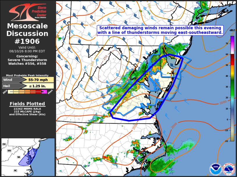
Mesoscale Discussion 1906 NWS Storm Prediction Center Norman OK 0528 PM CDT Mon Aug 10 2026 Areas affected...Parts of southeast VA into the Delmarva Peninsula and far southern NJ Concerning...Severe Thunderstorm Watch 556...558... Valid 102228Z - 110000Z The severe weather threat for Severe Thunderstorm Watch 556, 558 continues. SUMMARY...Scattered damaging winds remain possible this evening with a line of thunderstorms moving east-southeastward towards the Atlantic Coast. DISCUSSION...A well-developed squall line with a history of producing scattered wind damage across southern/central VA will continue to track east-southeastward this evening. The airmass ahead of the line remains moderately unstable, with surface temperatures generally in the upper 80s to low 90s, and dewpoints in the 70s. Even though mid-level lapse rates remain modest, daytime heating has supported steepening of low-level lapse rates. This, coupled with around 30-40 kt of mid-level west-northwesterlies, will likely support scattered damaging wind potential with the line for the next couple of hours as it approaches the Atlantic Coast. A couple of cells that have developed ahead of the line across far southeast VA may also pose an isolated risk for severe hail in the short term. A local extension in area for Severe Thunderstorm Watch 558 may be needed for the rest of southeast VA based on current trends. ..Gleason.. 08/10/2026 ...Please see www.spc.noaa.gov for graphic product... ATTN...WFO...PHI...AKQ...LWX... LAT...LON 36997829 37967733 38767634 39277564 39377526 39267477 39187456 38867470 38097510 37097586 36777628 36667732 36777814 36997829 MOST PROBABLE PEAK WIND GUST...55-70 MPH MOST PROBABLE PEAK HAIL SIZE...UP TO 1.25 IN |
|
|
Top/All Mesoscale Discussions/Forecast Products/Home |
|
Source link