

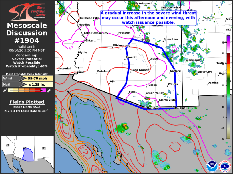
| Mesoscale Discussion 1904 | |
| < Previous MD | |

|
|
   Mesoscale Discussion 1904
   NWS Storm Prediction Center Norman OK
   0454 PM CDT Mon Aug 10 2026

   Areas affected...Parts of Arizona

   Concerning...Severe potential...Watch possible

   Valid 102154Z - 110030Z

   Probability of Watch Issuance...40 percent

   SUMMARY...A gradual increase in the severe wind threat may occur
   this afternoon and evening, with Severe Thunderstorm Watch issuance
   possible.

   DISCUSSION...A mid/upper-level anticyclone remains anchored over the
   Four Corners this afternoon, with modest (around 10-20 kt) easterly
   mid-level flow persisting across parts of NM/AZ per recent VWPs from
   KEMX. Modifying the 18Z observed sounding from PHX for current
   surface conditions shows a very well-mixed boundary layer through
   low/mid levels, with around 1600 J/kg of MLCAPE and ample DCAPE as
   well. This agrees with latest mesoanalysis estimates, which suggest
   around 1000-2000 J/kg of MLCAPE is present across the lower
   elevations of southeast/central AZ. Isolated to widely scattered
   thunderstorms have recently developed over the Mogollon Rim in
   east-central AZ and the higher terrain in southeast AZ. Recent
   trends in short-term model guidance remain unclear regarding
   potential for this activity to increase in coverage through the
   remainder of the afternoon, and whether one or more bowing clusters
   eventually develops westward into the lower deserts over the next
   few hours. Regardless of this continued uncertainty, the
   thermodynamic environment appears favorable for severe gusts if
   convection can grow upscale. Watch issuance is possible, and will
   largely depend on convective trends.

   ..Gleason/Mosier.. 08/10/2026

   ...Please see www.spc.noaa.gov for graphic product...

   ATTN...WFO...TWC...FGZ...PSR...

   LAT...LON   31701247 32351199 33181183 33931202 34351168 34181086
               33941010 32970944 31240938 31221104 31701247

   MOST PROBABLE PEAK WIND GUST...55-70 MPH
   MOST PROBABLE PEAK HAIL SIZE...UP TO 1.25 IN
|
|
|
Top/All Mesoscale Discussions/Forecast Products/Home |
|
Source link