

| Mesoscale Discussion 1899 | |
| < Previous MD | |

|
|
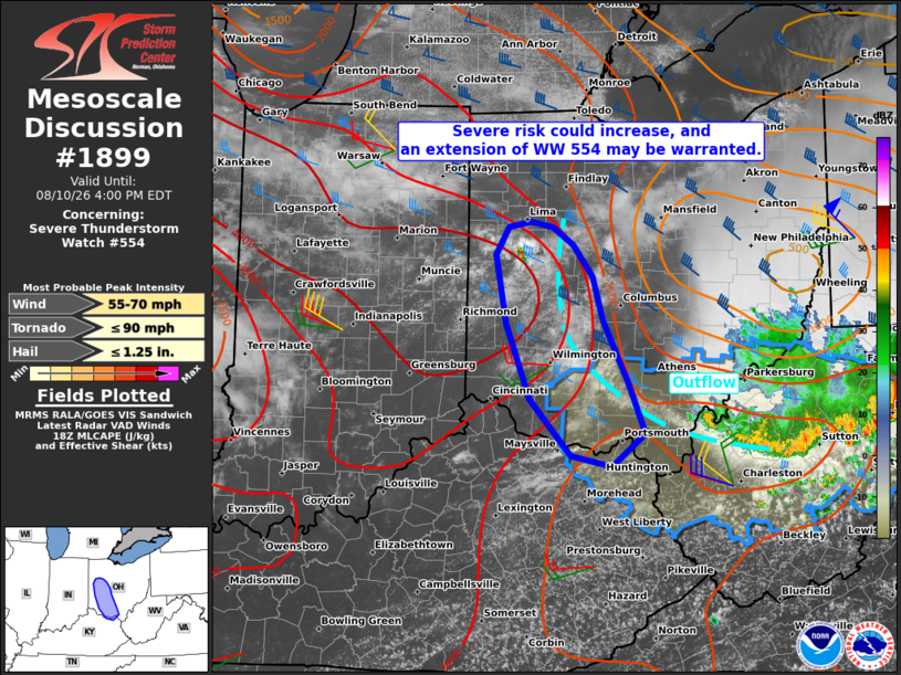
Mesoscale Discussion 1899 NWS Storm Prediction Center Norman OK 0129 PM CDT Mon Aug 10 2026 Areas affected...Portions of western Ohio Concerning...Severe Thunderstorm Watch 554... Valid 101829Z - 102000Z The severe weather threat for Severe Thunderstorm Watch 554 continues. SUMMARY...The risk of severe storms may be increasing in parts of western Ohio, and an extension of Severe Thunderstorm Watch #554 may be warranted. DISCUSSION...The latest visible satellite imagery shows deepening boundary-layer cumulus evolving in the vicinity of a N/S-oriented outflow boundary along the western flank of earlier convection that moved through central OH. Here, steep midlevel lapse rates atop a warm/moist PBL are contributing to a strongly unstable air mass. This, combined with around 30-40 kt of effective shear, may support intensification of thunderstorms along this corridor over the next few hours. There may be some tendency for storms to track eastward into the stabilized air mass, though any sustained storms that track southeastward along the boundary will be capable of producing damaging wind gusts and severe hail. An extension of Severe Thunderstorm Watch #554 may be warranted in parts of western OH to cover this risk. ..Weinman.. 08/10/2026 ...Please see www.spc.noaa.gov for graphic product... ATTN...WFO...RLX...ILN...IWX... LAT...LON 38588358 39108406 39798434 40418446 40668431 40728406 40678379 40518355 40228333 39828320 39248291 38798272 38488311 38588358 MOST PROBABLE PEAK TORNADO INTENSITY...UP TO 90 MPH MOST PROBABLE PEAK WIND GUST...55-70 MPH MOST PROBABLE PEAK HAIL SIZE...UP TO 1.25 IN |
|
|
Top/All Mesoscale Discussions/Forecast Products/Home |
|
Source link