

| Mesoscale Discussion 1891 | |
| < Previous MD | |

|
|
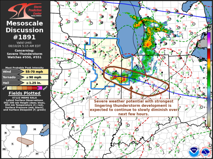
Mesoscale Discussion 1891 NWS Storm Prediction Center Norman OK 0215 AM CDT Mon Aug 10 2026 Areas affected...parts of east central Illinois...north central Indiana Concerning...Severe Thunderstorm Watch 550...551... Valid 100715Z - 100915Z The severe weather threat for Severe Thunderstorm Watch 550, 551 continues. SUMMARY...Scattered thunderstorm activity continues to develop east and south of the Lake Michigan vicinity, but the risk for additional severe weather appears to be lowering enough that a new severe weather watch is not anticipated. DISCUSSION...Lingering convection now generally spreading across and to the east/south of the southern Lake Michigan vicinity appears rooted within forcing for ascent associated with lower/mid-tropospheric warm advection. This is downstream of a low-amplitude short wave perturbation which is forecast to continue across the southwestern Great Lakes region overnight. A small clustering of storms now to the northwest of Danville IL appears the lone activity maintaining roots near the surface, within a boundary-layer characterized by seasonably high moisture content including dew points in the lower/mid 70s F. Located along a 30-35+ kt west-southwesterly 850 mb jet axis, near-surface hodographs are characterized by large clockwise curvature supportive of updraft rotation, though there is a weakness in flow further aloft, particularly with south/southeastward extent from the current position of the stronger convection. As activity continues to develop east-southeastward into a somewhat less moist air mass, any lingering risk for tornadoes seems likely to diminish. Potential for a couple of strong surface gusts may persist, but it is not clear that this will require a new severe weather watch. ..Kerr.. 08/10/2026 ...Please see www.spc.noaa.gov for graphic product... ATTN...WFO...IWX...IND...LOT...ILX... LAT...LON 41248795 40488488 39988603 40538793 40848853 41248795 MOST PROBABLE PEAK TORNADO INTENSITY...UP TO 90 MPH MOST PROBABLE PEAK WIND GUST...55-70 MPH MOST PROBABLE PEAK HAIL SIZE...UP TO 1.25 IN |
|
|
Top/All Mesoscale Discussions/Forecast Products/Home |
|
Source link