

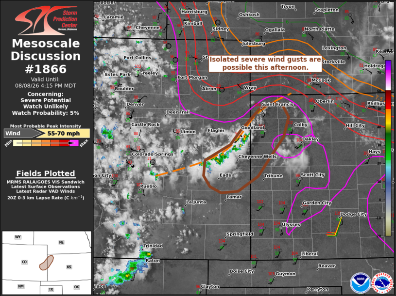
| Mesoscale Discussion 1866 | |
| < Previous MD | |

|
|
   Mesoscale Discussion 1866
   NWS Storm Prediction Center Norman OK
   0314 PM CDT Sat Aug 08 2026

   Areas affected...East-central CO into west-central/northwest KS

   Concerning...Severe potential...Watch unlikely

   Valid 082014Z - 082215Z

   Probability of Watch Issuance...5 percent

   SUMMARY...Isolated severe downbursts are possible this afternoon.

   DISCUSSION...Isolated high-based thunderstorms are evolving along a
   northeast/southwest-oriented surface boundary/wind shift extending
   from northwest KS into east-central CO this afternoon. Downstream of
   these storms, deep inverted-V profiles (around 65 deg T/Td spreads)
   will be favorable for isolated severe downbursts, despite the
   presence of weak buoyancy. Around 25-30 kt of west-northwesterly
   steering flow (per the GLD VWP) will allow this activity to continue
   spreading into western KS, where a continued risk of locally severe
   wind gusts will persist this afternoon.

   ..Weinman/Hart.. 08/08/2026

   ...Please see www.spc.noaa.gov for graphic product...

   ATTN...WFO...GLD...PUB...

   LAT...LON   39090251 39350228 39750182 39860151 39830129 39600114
               39240127 38510187 38240232 38210271 38320298 38520312
               38800309 39090251

   MOST PROBABLE PEAK WIND GUST...55-70 MPH
|
|
|
Top/All Mesoscale Discussions/Forecast Products/Home |
|
Source link