

| Mesoscale Discussion 1862 | |
| < Previous MD | |

|
|
   Mesoscale Discussion 1862
   NWS Storm Prediction Center Norman OK
   1055 AM CDT Sat Aug 08 2026

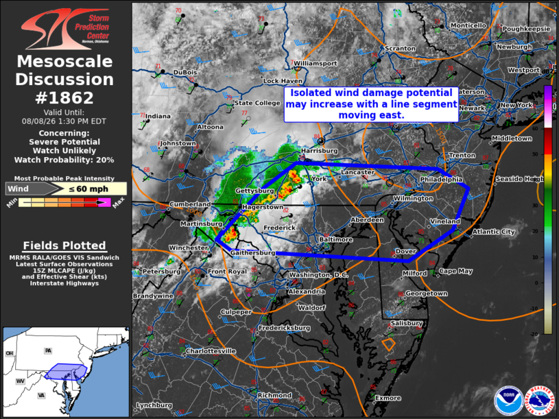
   Areas affected...Central Maryland into southern New Jersey

   Concerning...Severe potential...Watch unlikely

   Valid 081555Z - 081730Z

   Probability of Watch Issuance...20 percent

   SUMMARY...A line of thunderstorms may produce isolated wind damage,
   particularly as it nears the coast where the environment is more
   favorable. The need for a watch is not certain in the short term,
   but trends will be monitored.

   DISCUSSION...A loosely organized line of convection moving around 35
   kt to the east has shown modest signs of intensification/deepening
   per MRMS CAPPI data. A recent observation from Martinsburg, WV had a
   40 kt wind gust as the line moved through. KLWX radar velocity also
   suggests a slight enhancement to inbound velocities along the
   southern flank of the line. The morning observed IAD sounding had a
   dry pocket at low levels which has contributed to remaining MLCIN
   thus far. Closer to the coast, temperatures have been warming into
   the mid/upper 80s F and inhibition should be weaker there. It is
   possible that some increase in strong/damaging wind potential may
   occur as this line moves east early this afternoon. The main
   question is how widespread this threat will be. A watch is not
   anticipated in the short term, but observational trends will be
   monitored.

   ..Wendt/Hart.. 08/08/2026

   ...Please see www.spc.noaa.gov for graphic product...

   ATTN...WFO...PHI...CTP...LWX...

   LAT...LON   39217785 39327805 39897740 40187693 40127489 39907445
               39437467 39097532 39217785

   MOST PROBABLE PEAK WIND GUST...UP TO 60 MPH
|
|
|
Top/All Mesoscale Discussions/Forecast Products/Home |
|
Source link