

| Mesoscale Discussion 1857 | |
| < Previous MD Next MD > | |

|
|
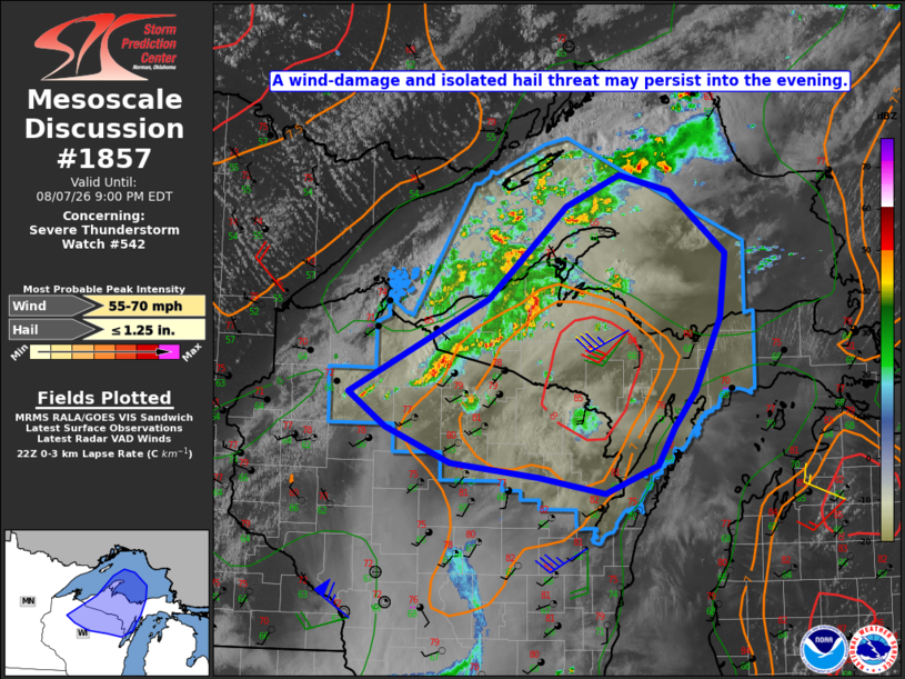
Mesoscale Discussion 1857 NWS Storm Prediction Center Norman OK 0553 PM CDT Fri Aug 07 2026 Areas affected...Northern WI into Upper MI Concerning...Severe Thunderstorm Watch 542... Valid 072253Z - 080100Z The severe weather threat for Severe Thunderstorm Watch 542 continues. SUMMARY...A wind-damage and isolated hail threat may continue into the evening. DISCUSSION...Loosely organized convection is ongoing from northern WI into western Upper MI and Lake Superior, along/ahead of a cold front. Earlier downstream heating has resulted in moderate destabilization, with MLCAPE of 1000-1500 J/kg (locally higher) per recent SPC objective mesoanalyses. Deep-layer shear is relatively modest, though some enhancement to flow in the lowest 2 km (per VWPs from KMQT) is resulting in effective SRH of 100-150 m2/s2, sufficient for at least modest storm organization. A pocket of relatively steep lapse rates will favor continued wind-damage potential from northeast WI into western/central Upper MI through the early evening. Isolated hail also cannot be ruled out with the strongest embedded cells. The greatest storm coverage may tend to remain across Upper MI, though additional development cannot be ruled out across northern WI, north of an extensive cirrus shield covering the bulk of the state. ..Dean.. 08/07/2026 ...Please see www.spc.noaa.gov for graphic product... ATTN...WFO...MQT...GRB...DLH...ARX...MPX... LAT...LON 45939129 46818942 47668837 47958765 47808697 47228622 46628630 45948665 45628692 45258715 44998786 45148875 45288991 45619078 45939129 MOST PROBABLE PEAK WIND GUST...55-70 MPH MOST PROBABLE PEAK HAIL SIZE...UP TO 1.25 IN |
|
|
Top/All Mesoscale Discussions/Forecast Products/Home |
|
Source link