

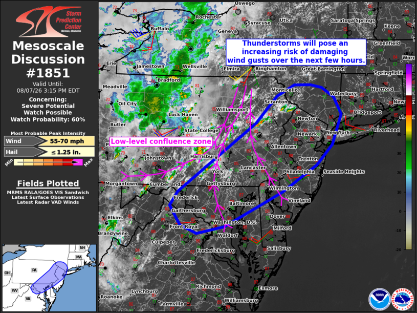
| Mesoscale Discussion 1851 | |
| < Previous MD | |

|
|
   Mesoscale Discussion 1851
   NWS Storm Prediction Center Norman OK
   1150 AM CDT Fri Aug 07 2026

   Areas affected...Parts of the Mid-Atlantic

   Concerning...Severe potential...Watch possible

   Valid 071650Z - 071915Z

   Probability of Watch Issuance...60 percent

   SUMMARY...Thunderstorms will pose an increasing risk of damaging
   wind gusts over the next few hours. A watch is being considered for
   parts of the area.

   DISCUSSION...Thunderstorms are gradually increasing in coverage
   across parts of central/eastern PA, focused within a zone of
   low-level confluence. Over the next few hours, modest midlevel
   height falls preceding a midlevel trough and continued diurnal
   heating of a moist air mass will remove any remaining inhibition and
   promote scattered thunderstorms. Around 20-30 kt of midlevel
   southwesterly flow and moderate-strong surface-based
   buoyancy/steepening low-level lapse rates will support loosely
   organized clusters capable of producing scattered damaging wind
   gusts through the afternoon. The greatest damaging-wind risk will
   generally spread from west to east across the area this afternoon,
   and a watch is being considered.

   ..Weinman/Gleason.. 08/07/2026

   ...Please see www.spc.noaa.gov for graphic product...

   ATTN...WFO...OKX...ALY...PHI...BGM...CTP...LWX...

   LAT...LON   39607796 41027586 41597528 41827480 41837436 41767405
               41577371 41207352 40577378 40167421 39597515 38877669
               38727744 38917790 39307817 39607796

   MOST PROBABLE PEAK WIND GUST...55-70 MPH
   MOST PROBABLE PEAK HAIL SIZE...UP TO 1.25 IN
|
|
|
Top/All Mesoscale Discussions/Forecast Products/Home |
|
Source link