

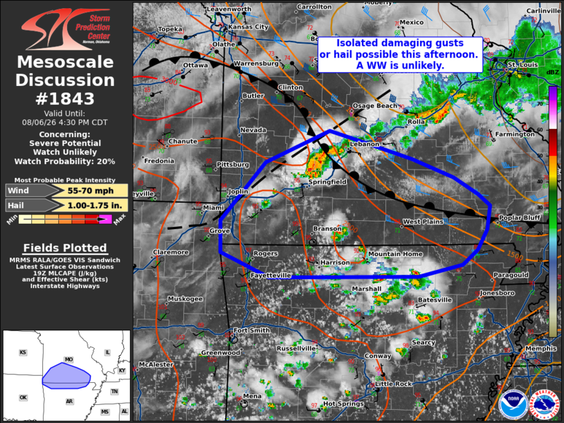
| Mesoscale Discussion 1843 | |
| < Previous MD | |

|
|
   Mesoscale Discussion 1843
   NWS Storm Prediction Center Norman OK
   0257 PM CDT Thu Aug 06 2026

   Areas affected...parts of southern Missouri and far northern
   Arkansas

   Concerning...Severe potential...Watch unlikely

   Valid 061957Z - 062130Z

   Probability of Watch Issuance...20 percent

   SUMMARY...Clusters of strong to occasional severe storms along a
   surface front/outflow boundary intersection may pose a risk for
   isolated damaging gusts or hail. A WW currently appears unlikely.

   DISCUSSION...As of 1955 UTC, regional radar imagery showed
   thunderstorms increasing in coverage and intensity across portions
   of southern MO and the Ozark Plateau. The air mass ahead of these
   storms has gradually warmed and destabilized in response to partial
   clearing near a stalled surface front and outflow intersection from
   prior convection. 1500-2500 J/kg of MLCAPE will likely support the
   ongoing storms and additional development this afternoon as surface
   temperatures continue to warm into the mid to upper 90s F. While
   lapse rates are not all that steep, enhanced low-level convergence
   and the moderate buoyancy could support some hail with the storms
   along the front. Damaging gusts are also possible given the high
   PWAT content (1.5-1.9 inches) and potential for downbursts.

   The primary limiting factor is the small spatial extent of the more
   unstable air mass and lack of stronger vertical shear. With area RAP
   soundings showing effective shear on the order of 25-35 kt primarily
   on the cool side of the boundary, storm organization is likely to be
   transient and focused along the narrow frontal axis. This suggests
   an overall isolated severe risk. Convective trends will be
   monitored, but a watch is not currently anticipated.

   ..Lyons/Gleason.. 08/06/2026

   ...Please see www.spc.noaa.gov for graphic product...

   ATTN...WFO...PAH...MEG...LSX...LZK...SGF...TSA...

   LAT...LON   36119277 36109386 36399460 36789461 37519392 37899295
               37769246 37549167 37319104 37119068 36979049 36679054
               36429070 36259092 36119160 36119277

   MOST PROBABLE PEAK WIND GUST...55-70 MPH
   MOST PROBABLE PEAK HAIL SIZE...1.00-1.75 IN
|
|
|
Top/All Mesoscale Discussions/Forecast Products/Home |
|
Source link