

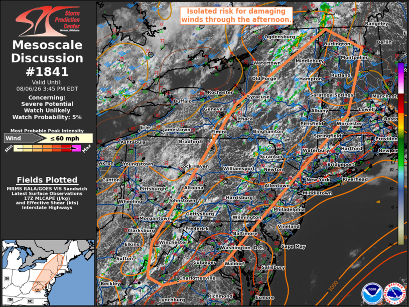
| Mesoscale Discussion 1841 | |
| < Previous MD | |

|
|
   Mesoscale Discussion 1841
   NWS Storm Prediction Center Norman OK
   1239 PM CDT Thu Aug 06 2026

   Areas affected...portions of the Northeast and Mid-Atlantic

   Concerning...Severe potential...Watch unlikely

   Valid 061739Z - 061945Z

   Probability of Watch Issuance...5 percent

   SUMMARY...Thunderstorm coverage to increase through the afternoon
   with potential for a few isolated instances of damaging wind.

   DISCUSSION...Thunderstorm coverage is expected to steadily increase
   through the afternoon, aided by daytime heating and moistening near
   the surface trough and ascent near the higher terrain. Steep
   low-level lapse rates, 20-30 kts of deep layer shear, and moderate
   instability will support potential for a few isolated stronger
   clusters/segments spreading east with potential for wet downbursts.
   This threat is expected to remain too localized to warrant watch
   issuance.

   ..Thornton/Gleason.. 08/06/2026

   ...Please see www.spc.noaa.gov for graphic product...

   ATTN...WFO...GYX...BOX...BTV...OKX...ALY...PHI...BGM...AKQ...
   BUF...CTP...LWX...RNK...PBZ...RLX...

   LAT...LON   39077944 42927651 44967308 44417171 42617233 38487694
               38187753 38047837 37917900 38117950 38207953 39077944

   MOST PROBABLE PEAK WIND GUST...UP TO 60 MPH
|
|
|
Top/All Mesoscale Discussions/Forecast Products/Home |
|
Source link