

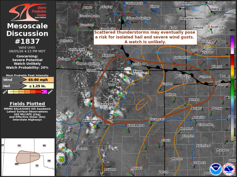
| Mesoscale Discussion 1837 | |
| < Previous MD | |

|
|
   Mesoscale Discussion 1837
   NWS Storm Prediction Center Norman OK
   0313 PM CDT Wed Aug 05 2026

   Areas affected...portions of the Raton Mesa in New Mexico/Colorado
   into the western Texas/Oklahoma Panhandles

   Concerning...Severe potential...Watch unlikely

   Valid 052013Z - 052215Z

   Probability of Watch Issuance...20 percent

   SUMMARY...Weak upslope flow and strong heating across the higher
   terrain should support scattered thunderstorms this afternoon and
   into the evening. A few strong to severe storms are possible with
   isolated hail or severe wind gusts possible. Organization and
   coverage of the stronger storms should be limited and a Watch
   appears unlikely.

   DISCUSSION...As of 20 UTC, visible imagery showed initial updrafts
   along the crest of the Sangre De Cristos Range and Raton Mesa were
   deepening. Weak upslope flow and diurnal heating south of a
   quasi-stationary front will continue to support destabilization this
   afternoon. RAP soundings show convective temperatures in the mid 80s
   to low 90s F are gradually being reached which should remove most
   inhibition over the next 1-2 hours. This, along with the weak
   upslope flow and a passing weak mid-level trough should support an
   increase in storm coverage through the afternoon.

   The air mass over the southern High Plains is hot and moderately
   unstable with SPC mesosanalysis showing 1000-1500 J/kg of MLCAPE and
   mid-level lapse rates around 8 C/km by late afternoon. This will be
   sufficient to support stronger updrafts initially over the higher
   terrain. Deep-layer shear is not overly strong (20-30 kt), but
   should allow the storms to move off the higher terrain and
   strengthen with time, especially into this evening as a 25+ kt
   southerly low-level jet is forecast to develop. This could support
   some organized multicell structures or transient supercells.

   Convection should gradually intensify this afternoon before moving
   into the High Plains later today. Isolated hail is possible with the
   initial cellular storms, but steep lapse rates and a relatively dry
   sub-cloud layer should favor strong/isolated severe gusts.
   Clustering of outflow could also support a gust of 75+ mph.

   While some severe risk is expected to increase over the next few
   hours, overall forcing remains weak. This, along with lingering
   inhibition and modest buoyancy, suggest storm organization will be
   limited. As such, a WW currently appears unlikely, though trends
   will be monitored should any more focused corridors of severe
   potential emerge.

   ..Lyons/Gleason.. 08/05/2026

   ...Please see www.spc.noaa.gov for graphic product...

   ATTN...WFO...DDC...AMA...PUB...ABQ...

   LAT...LON   37500507 37290356 37160187 36910112 36640081 36240084
               35870114 35460254 35270324 35140412 35130475 35040533
               35120552 35360602 35600619 35920621 36310618 36700589
               37350549 37500507

   MOST PROBABLE PEAK WIND GUST...65-80 MPH
   MOST PROBABLE PEAK HAIL SIZE...UP TO 1.25 IN
|
|
|
Top/All Mesoscale Discussions/Forecast Products/Home |
|
Source link