

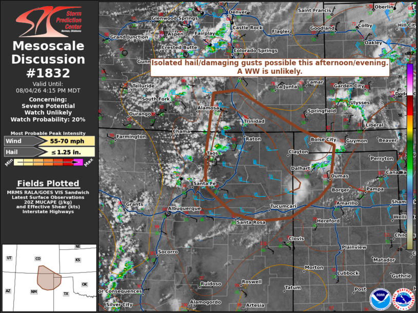
| Mesoscale Discussion 1832 | |
| < Previous MD | |

|
|
   Mesoscale Discussion 1832
   NWS Storm Prediction Center Norman OK
   0322 PM CDT Tue Aug 04 2026

   Areas affected...parts of far southeastern Colorado...northeast New
   Mexico and the western Texas/Oklahoma Panhandles

   Concerning...Severe potential...Watch unlikely

   Valid 042022Z - 042215Z

   Probability of Watch Issuance...20 percent

   SUMMARY...Initial convection over the higher terrain should
   gradually increase in coverage late this afternoon. Isolated hail
   and damaging gusts are possible with the strongest storms. A WW is
   unlikely.

   DISCUSSION...As of 2015 UTC, visible imagery showed increased
   vertical development of cumulus along the ridge tops of the Raton
   Mesa and Sangre De Cristos Range. Strong surface heating amid a weak
   post-frontal upslope flow regime is supporting gradual air mass
   destabilization which is forecast to continue much of this
   afternoon. While not overly robust, around 1000 J/kg of MUCAPE and
   mid-level lapse rates ~ 8 C/km will be sufficient to support strong
   updrafts as convection intensifies.

   Current expectations are for storms to gradually develop and move
   off the higher terrain onto the southern High Plains, aided by
   modestly enhanced westerly flow aloft. As convection intensifies
   late this afternoon/evening, some organization into multicell
   clusters or transient supercells is possible owing to 30-35 kts of
   deep-layer shear. This could support isolated hail with the stronger
   storms, along with some potential for damaging/severe gusts with
   low-level lapse rates being fairly steep. While some severe risk is
   possible into this evening, modest forcing for ascent and buoyancy
   suggest the threat will be isolated. A WW is unlikely.

   ..Lyons/Gleason.. 08/04/2026

   ...Please see www.spc.noaa.gov for graphic product...

   ATTN...WFO...AMA...PUB...ABQ...

   LAT...LON   37900537 37990466 37040278 36660181 35750196 35440227
               34980311 34890400 35070475 35420522 35650550 35980556
               36430556 37900537

   MOST PROBABLE PEAK WIND GUST...55-70 MPH
   MOST PROBABLE PEAK HAIL SIZE...UP TO 1.25 IN
|
|
|
Top/All Mesoscale Discussions/Forecast Products/Home |
|
Source link