

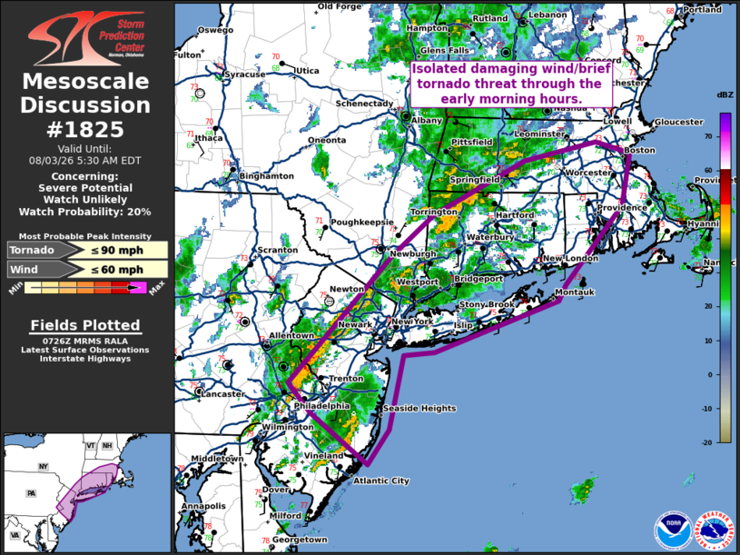
| Mesoscale Discussion 1825 | |
| < Previous MD | |

|
|
   Mesoscale Discussion 1825
   NWS Storm Prediction Center Norman OK
   0228 AM CDT Mon Aug 03 2026

   Areas affected...New Jersey into southeast New York and Connecticut
   and into Rhode Island and southeast Massachusetts

   Concerning...Severe potential...Watch unlikely

   Valid 030728Z - 030930Z

   Probability of Watch Issuance...20 percent

   SUMMARY...An isolated damaging wind/brief tornado threat will exist
   through the early morning hours.

   DISCUSSION...A recent uptick in convective intensity (including
   increasing lightning) has been observed with storms from New Jersey
   into Connecticut over the past 30 to 45 minutes. These storms are
   aided by broad isentropic ascent (40 knot low-level jet sampled by
   the OKX VWP) and weak height falls. This strong low-level jet,
   combined with backed low-level southeasterly flow ahead of a
   deepening surface low across central New York has resulted in
   relatively strong low-level shear. In addition, mid to upper 70s
   dewpoints are in place, resulting in a very moist low-level air mass
   and MLCAPE around 1500 J/kg (per SPC HRRR-based mesoanalysis). Storm
   mode is messy, due to a combination of storm mergers and a very
   moist air mass (2.31 PWAT per IAD 00Z RAOB). These lapse rates and
   the messy storm mode should preclude the need for a watch. However,
   the very moist low-level air mass and moderately strong low-level
   shear could result in isolated damaging wind gusts and perhaps a
   tornado.

   ..Bentley/Smith.. 08/03/2026

   ...Please see www.spc.noaa.gov for graphic product...

   ATTN...WFO...BOX...OKX...ALY...PHI...

   LAT...LON   39467423 39947493 40237522 41447394 41827344 42327229
               42497139 42387096 41907106 41157179 41017188 40537342
               40497379 39797397 39467423

   MOST PROBABLE PEAK TORNADO INTENSITY...UP TO 90 MPH
   MOST PROBABLE PEAK WIND GUST...UP TO 60 MPH
|
|
|
Top/All Mesoscale Discussions/Forecast Products/Home |
|
Source link