

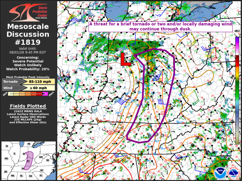
| Mesoscale Discussion 1819 | |
| < Previous MD | |

|
|
   Mesoscale Discussion 1819
   NWS Storm Prediction Center Norman OK
   0644 PM CDT Sat Aug 01 2026

   Areas affected...Parts of eastern IN/KY...western
   OH...middle/eastern TN

   Concerning...Severe potential...Watch unlikely

   Valid 012344Z - 020145Z

   Probability of Watch Issuance...20 percent

   SUMMARY...A threat for a brief tornado or two and/or locally
   damaging wind may continue through dusk.

   DISCUSSION...An arc of thunderstorms is ongoing this evening from
   eastern IN into southwest OH, eastern KY, and middle TN, in
   association with a broad deep-layer clone over IL/IN and surface
   trough that trails into the OH/TN Valleys. Multiple cells within
   convective arc have developed brief/transient rotation over the last
   1-2 hours, aided by low-level vorticity near the surface cyclone and
   some SRH enhancement noted on the KILN VWP. Rich low-level moisture
   is supporting MLCAPE of 1000-2000 J/kg, though poor lapse rates may
   continue to temper updraft intensity and the longevity of the severe
   threat with any particular storm. The strongest cells through dusk
   will remain capable of producing a brief tornado or two and/or
   locally damaging winds.

   ..Dean/Hart.. 08/01/2026

   ...Please see www.spc.noaa.gov for graphic product...

   ATTN...WFO...RLX...MRX...JKL...ILN...LMK...IWX...OHX...IND...

   LAT...LON   40158575 40508445 40428362 40058303 39198303 37968341
               37018369 36298411 35658475 35598531 35638557 35758612
               35988613 36678568 37878514 39618506 40158575

   MOST PROBABLE PEAK TORNADO INTENSITY...85-110 MPH
   MOST PROBABLE PEAK WIND GUST...UP TO 60 MPH
|
|
|
Top/All Mesoscale Discussions/Forecast Products/Home |
|
Source link