

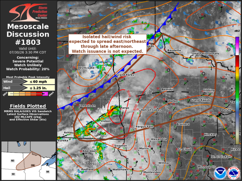
| Mesoscale Discussion 1803 | |
| < Previous MD | |

|
|
   Mesoscale Discussion 1803
   NWS Storm Prediction Center Norman OK
   0137 PM CDT Thu Jul 30 2026

   Areas affected...Eastern North Dakota into northern Minnesota

   Concerning...Severe potential...Watch unlikely

   Valid 301837Z - 302030Z

   Probability of Watch Issuance...20 percent

   SUMMARY...Thunderstorms developing along a diffuse frontal zone may
   pose a severe wind threat through the afternoon hours across eastern
   North Dakota and northern Minnesota. However, a limited kinematic
   environment will likely modulate overall convective
   intensity/organization and negate the need for watch issuance.

   DISCUSSION...Thunderstorms have been slowly deepening along a subtle
   pre-frontal convergence zone across southeast ND over the past 30-60
   minutes with MRMS VIL showing steady growth of embedded convective
   cores within a broader broken line of storms. This more intense
   convection is being focused within a plume of relatively richer
   low-level moisture where MLCAPE is being analyzed around 3000 J/kg.
   Although entrainment is likely yielding MLCAPE values closer to
   1500-2000 J/kg, the richer low-level moisture and focused low-level
   convergence will likely promote further thunderstorm development in
   the coming hours, especially as the primary cold front migrates
   southeast.

   The nearby KMVX VWP is currently sampling a somewhat modest wind
   profile. 5-7 km winds between 20-30 knots are yielding 0-6 km BWD
   values on the order of 20-25 knots. While this is generally
   sufficient for some degree of storm organization, the recent demise
   of a storm north of KMVX casts uncertainty on how supportive the
   kinematic environment is for sustained organized convection.

   Nonetheless, as the emerging cluster continues to evolve, embedded
   deep convective cores may pose an isolated/transient hail risk, and
   some degree of strong/severe wind threat is anticipated as storms
   spread east/northeast down a buoyancy axis and ahead of the front
   into MN through late afternoon. In general, convective intensity
   should remain sufficiently limited to preclude the need for watch
   issuance.

   ..Moore/Mosier.. 07/30/2026

   ...Please see www.spc.noaa.gov for graphic product...

   ATTN...WFO...DLH...FGF...ABR...BIS...

   LAT...LON   46749311 45909746 45859827 45889861 46029884 46359890
               46749872 47769700 49009518 49309477 48559241 48309224
               47939228 47639233 47329236 46919256 46749311

   MOST PROBABLE PEAK WIND GUST...UP TO 60 MPH
   MOST PROBABLE PEAK HAIL SIZE...UP TO 1.25 IN
|
|
|
Top/All Mesoscale Discussions/Forecast Products/Home |
|
Source link