

| Mesoscale Discussion 1788 | |
| < Previous MD | |

|
|
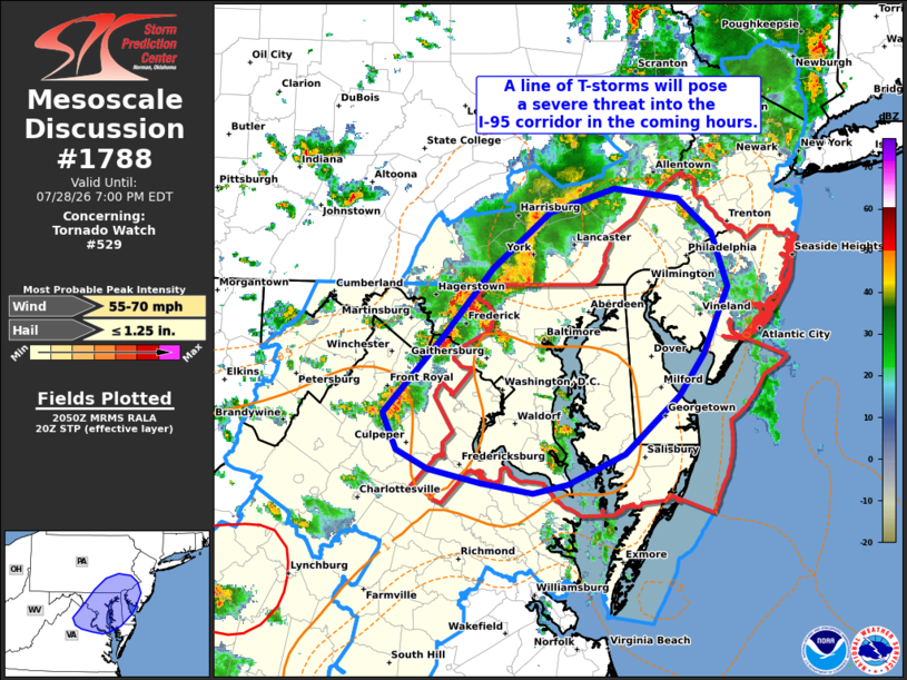
Mesoscale Discussion 1788 NWS Storm Prediction Center Norman OK 0353 PM CDT Tue Jul 28 2026 Areas affected...portions of the Mid-Atlantic Concerning...Tornado Watch 529... Valid 282053Z - 282300Z The severe weather threat for Tornado Watch 529 continues. SUMMARY...A consolidating line of storms will continue to pose a risk of damaging/severe winds, and perhaps some tornado threat, across the Mid-Atlantic region over the next few hours. DISCUSSION...Latest radar imagery from KLWX and KCCX show the continued consolidation of a line of thunderstorms across south-central PA into northern VA. Although most wind reports have remained in the 35-45 mph range, several instances of wind damage have been noted, and KLWX velocity imagery depicts at least a couple of embedded swaths of stronger winds. Downstream, temperatures have warmed into the 80s, which is supporting a pocket of MLCAPE near 1500 J/kg. Additionally, the KLWX VWP is sampling a nearly straight hodograph featuring around 45 knots of 0-6 km BWD. This thermodynamic/kinematic environment should be favorable for continued organization of the line and an attendant threat for damaging/severe winds as it approaches the I-95 corridor over the next 1-2 hours. While severe winds remain the primary concern, adequate low-level wind shear orthogonal to the developing line may support a few embedded circulations. ..Moore.. 07/28/2026 ...Please see www.spc.noaa.gov for graphic product... ATTN...WFO...PHI...AKQ...CTP...LWX... LAT...LON 38697824 39317762 39857712 40297654 40487589 40397523 40127489 39697473 39177498 38837523 38387578 38147637 38077672 38157725 38267777 38417809 38697824 MOST PROBABLE PEAK WIND GUST...55-70 MPH MOST PROBABLE PEAK HAIL SIZE...UP TO 1.25 IN |
|
|
Top/All Mesoscale Discussions/Forecast Products/Home |
|
Source link