

| Mesoscale Discussion 1786 | |
| < Previous MD Next MD > | |

|
|
   Mesoscale Discussion 1786
   NWS Storm Prediction Center Norman OK
   0331 PM CDT Tue Jul 28 2026

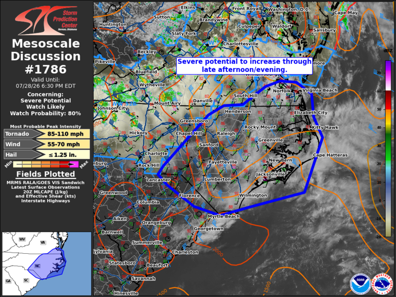
   Areas affected...portions of southeastern Virginia...eastern North
   Carolina...portions of northern South Carolina

   Concerning...Severe potential...Watch likely

   Valid 282031Z - 282230Z

   Probability of Watch Issuance...80 percent

   SUMMARY...Severe potential to increase through the evening.

   DISCUSSION...Mid-level cloud cover has been in place across much of
   North Carolina to the coast through the morning/early afternoon.
   This has led to slow air mass recovery behind morning convection. A
   few breaks in the clouds are shifting eastward, with a few hours of
   daytime heating left for recovery. Temperatures have warmed into the
   mid to upper 80s. With additional heating, it is likely that at
   least marginal to moderate instability will return across the area
   ahead of the approaching front/thunderstorms from the east. This
   along with strengthening deep layer shear may support potential for
   a few organized clusters/embedded supercells and increasing severe
   potential this evening. The main threats will be damaging wind,
   large hail, and perhaps a tornado. A watch will be needed in the
   next couple of hours to cover this potential.

   ..Thornton/Hart.. 07/28/2026

   ...Please see www.spc.noaa.gov for graphic product...

   ATTN...WFO...AKQ...MHX...RAH...ILM...CAE...GSP...

   LAT...LON   35018023 36327888 36567839 36597781 37037710 37177664
               37137613 36837566 36257560 35737534 34377594 34017762
               33797848 34017927 34548009 34798038 35018023

   MOST PROBABLE PEAK TORNADO INTENSITY...85-110 MPH
   MOST PROBABLE PEAK WIND GUST...55-70 MPH
   MOST PROBABLE PEAK HAIL SIZE...UP TO 1.25 IN
|
|
|
Top/All Mesoscale Discussions/Forecast Products/Home |
|
Source link