

| Mesoscale Discussion 1755 | |
| < Previous MD | |

|
|
   Mesoscale Discussion 1755
   NWS Storm Prediction Center Norman OK
   1154 PM CDT Sun Jul 26 2026

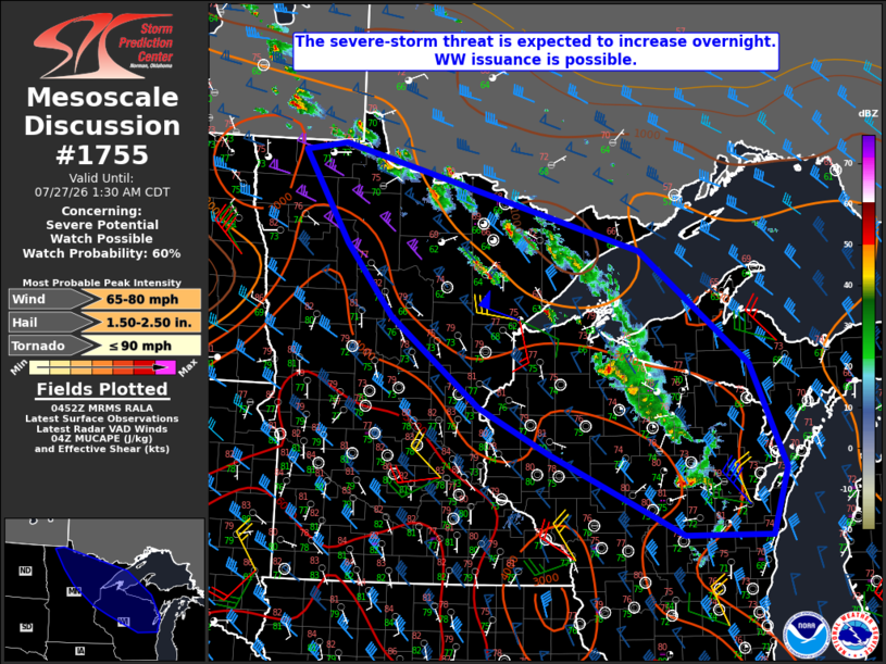
   Areas affected...Northern MN/WI into western/central Upper MI

   Concerning...Severe potential...Watch possible

   Valid 270454Z - 270630Z

   Probability of Watch Issuance...60 percent

   SUMMARY...The severe-storm threat is expected to increase overnight,
   and watch issuance is possible.

   DISCUSSION...Elevated convection continues across parts of northern
   MN/WI late this evening, to the cool side of a nearly stationary
   baroclinic zone. The environment remains conditionally favorable
   across the region, with MUCAPE in excess of 2000 J/kg and strong
   deep-layer shear. In the short term, the strongest elevated storms
   will be capable of producing isolated large hail and damaging gusts.

   Most guidance continues to depict an increase in storm coverage and
   eventual clustering/upscale growth, though this evolution has been
   slow to materialize thus far. Increasing low-level warm advection
   should eventually result in additional storm development, resulting
   in an increasing severe threat overnight. Watch issuance is possible
   if trends begin to support intensification of ongoing cells and/or
   incipient upscale growth.

   ..Dean/Smith.. 07/27/2026

   ...Please see www.spc.noaa.gov for graphic product...

   ATTN...WFO...MQT...GRB...DLH...ARX...MPX...FGF...

   LAT...LON   48979545 47689001 46258806 44948742 44108771 44118926
               45159168 45719292 46849452 47739536 48889620 48979545

   MOST PROBABLE PEAK TORNADO INTENSITY...UP TO 90 MPH
   MOST PROBABLE PEAK WIND GUST...65-80 MPH
   MOST PROBABLE PEAK HAIL SIZE...1.50-2.50 IN
|
|
|
Top/All Mesoscale Discussions/Forecast Products/Home |
|
Source link