

| Mesoscale Discussion 1749 | |
| < Previous MD | |

|
|
   Mesoscale Discussion 1749
   NWS Storm Prediction Center Norman OK
   0734 PM CDT Sun Jul 26 2026

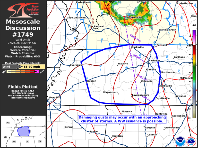
   Areas affected...portions of western into middle Tennessee

   Concerning...Severe potential...Watch possible

   Valid 270034Z - 270130Z

   Probability of Watch Issuance...60 percent

   SUMMARY...Damaging gusts, a few of which may be severe, are expected
   to accompany an approaching MCS. If the MCS maintains intensity
   while approaching the KY/TN border over the next hour or so, a WW
   issuance may be needed.

   DISCUSSION...A cold-pool-driven MCS, with a history of wind damage,
   continues propagate south-southeast at approximately 40 kts. It is
   plausible that this MCS will maintain intensity given the
   combination of 4500+ J/kg MLCAPE and 35-40 kts of effective bulk
   shear (oriented perpendicular to the leading line) preceding the
   cluster. Assuming this remains the case, the MCS is poised to enter
   TN by around 0130Z. A Severe Thunderstorm Watch issuance may be
   needed beforehand to address the impending severe threat if this MCS
   maintains its current intensity.

   ..Squitieri/Smith.. 07/27/2026

   ...Please see www.spc.noaa.gov for graphic product...

   ATTN...WFO...OHX...HUN...PAH...MEG...

   LAT...LON   36168899 36408859 36538818 36638744 36628666 36388650
               35848638 35348647 35138662 35028682 35038759 35068816
               35098839 35208867 36168899

   MOST PROBABLE PEAK WIND GUST...55-70 MPH
|
|
|
Top/All Mesoscale Discussions/Forecast Products/Home |
|
Source link