

| Mesoscale Discussion 1741 | |
| < Previous MD | |
|
|
   Mesoscale Discussion 1741
   NWS Storm Prediction Center Norman OK
   0120 PM CDT Sun Jul 26 2026

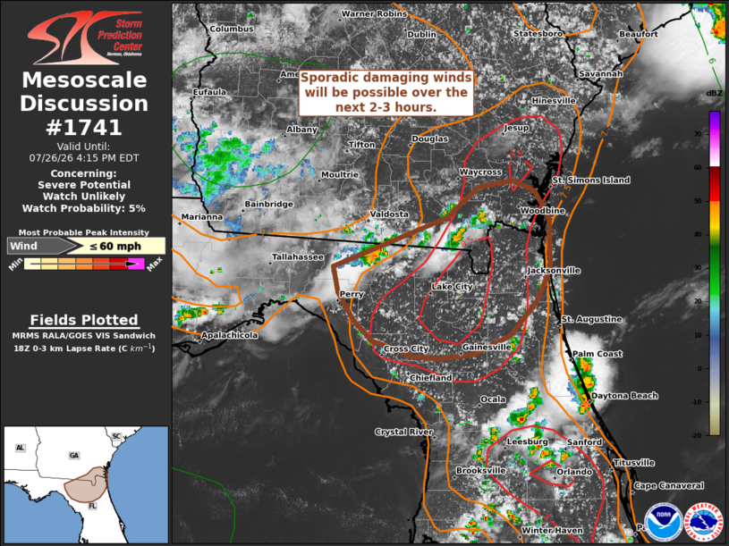
   Areas affected...Far southeast Georgia into northern Florida

   Concerning...Severe potential...Watch unlikely

   Valid 261820Z - 262015Z

   Probability of Watch Issuance...5 percent

   SUMMARY...Weak thunderstorms are moving into an environment
   favorable for strong downbursts capable of producing damaging winds.
   Watch issuance is not expected, but some wind threat may materialize
   over the next 2-3 hours across far southeast Georgia into northern
   Florida.

   DISCUSSION...KVAX and KJAX radar and GOES imagery shows steady
   growth of poorly organized convection across south-central GA with
   embedded swaths of strong winds noted in velocity imagery and
   confirmed by a recent report of 39 mph. Downstream of this activity,
   strong diurnal heating has allow temperatures to warm into the 90s
   with dewpoint depressions increasing to around 20 F. Boundary-layer
   depth/mixing has deepened sufficiently such that low-level lapse
   rates have increased to 8 to 8.5 C/km across northern FL into far
   southeast GA. Additionally, a subtle buoyancy axis is noted across
   this same zone. The potential for strong downbursts should increase
   over the next couple of hours as thunderstorms move into this
   thermodynamic environment. Regional VWPs continue to sample very
   weak deep-layer wind shear, which suggests that storm
   organization/longevity (and the overall severe threat) will continue
   to be limited. Nonetheless, based on the thermodynamic environment
   and recent reports downbursts may be capable of producing 40-60 mph
   gusts.

   ..Moore/Leitman.. 07/26/2026

   ...Please see www.spc.noaa.gov for graphic product...

   ATTN...WFO...JAX...TAE...

   LAT...LON   30428363 30868245 31138213 31188177 31108155 30858141
               30398140 30108154 29808181 29638217 29598252 29618281
               29758323 29948341 30188357 30428363

   MOST PROBABLE PEAK WIND GUST...UP TO 60 MPH
|
|
|
Top/All Mesoscale Discussions/Forecast Products/Home |
|
Source link