

| Mesoscale Discussion 1734 | |
| < Previous MD Next MD > | |

|
|
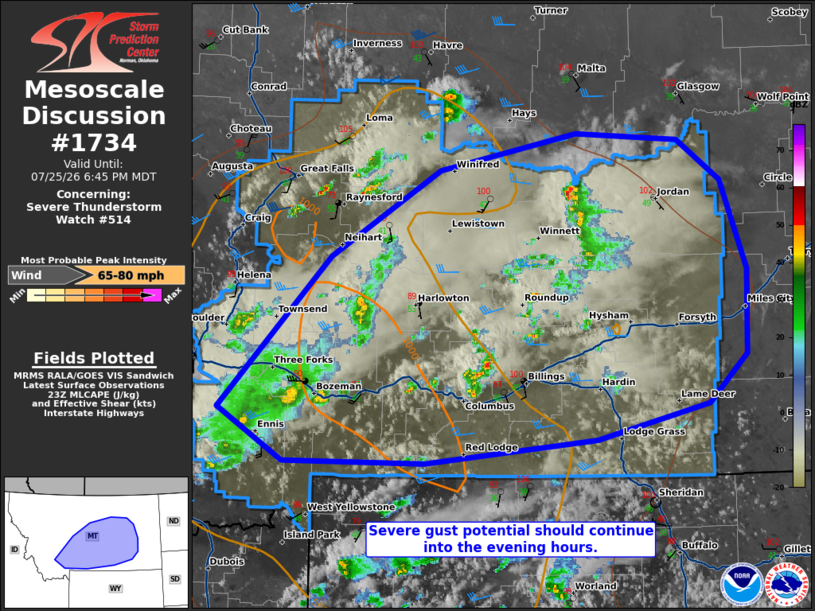
Mesoscale Discussion 1734 NWS Storm Prediction Center Norman OK 0613 PM CDT Sat Jul 25 2026 Areas affected...portions of central into southern Montana Concerning...Severe Thunderstorm Watch 514... Valid 252313Z - 260045Z The severe weather threat for Severe Thunderstorm Watch 514 continues. SUMMARY...Severe gusts remain a concern through the evening hours with the stronger, longer-lived storms. A gust or two could exceed 75 mph. DISCUSSION...Pulse cellular and multicellular storms continue to track across central and southern MT, amid a modestly unstable and sheared airmass. Surface temperatures remain above 100 F, amid mid 40s F dewpoints ahead of the storms, yielding 50+ F surface T/Td spreads. DCAPE exceeds 2000 J/kg in some locales (per 23Z mesoanalysis). As such, enough evaporative cooling with the deeper storm cores will support downbursts easily capable of producing 60+ mph gusts, a couple of which may also exceed 75 mph. ..Squitieri/Hart.. 07/25/2026 ...Please see www.spc.noaa.gov for graphic product... ATTN...WFO...BYZ...GGW...TFX... LAT...LON 45551219 46821085 47560953 47870787 47810664 47470611 46720581 46000583 45590628 45300764 45090970 45111141 45551219 MOST PROBABLE PEAK WIND GUST...65-80 MPH |
|
|
Top/All Mesoscale Discussions/Forecast Products/Home |
|
Source link