

| Mesoscale Discussion 1723 | |
| < Previous MD | |

|
|
   Mesoscale Discussion 1723
   NWS Storm Prediction Center Norman OK
   0249 PM CDT Fri Jul 24 2026

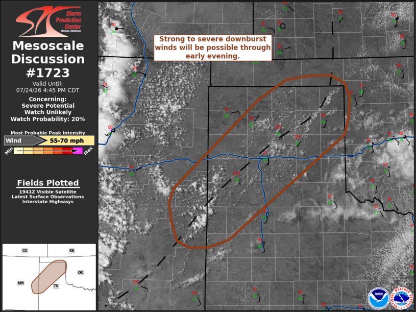
   Areas affected...Eastern New Mexico into the Texas Panhandle

   Concerning...Severe potential...Watch unlikely

   Valid 241949Z - 242145Z

   Probability of Watch Issuance...20 percent

   SUMMARY...Thunderstorm development across far eastern New Mexico and
   into the Texas Panhandle is expected within the next 1-2 hours.
   Storms will be capable of producing strong to severe downburst
   winds, but this threat will remain fairly isolated and negate the
   need for a watch.

   DISCUSSION...Latest GOES visible imagery shows cumulus development
   along a weak trough axis draped from eastern NM into the
   northeastern TX Panhandle. Modifying a recent 18 UTC AMA sounding
   using recent surface observations (which feature temperatures
   quickly warming into the upper 90s and low 100s with 55-60 F
   dewpoints) suggests that MLCIN has largely been eroded by the warm
   temperatures and MLCAPE has likely increased to 2000-2500 J/kg. The
   rate of cumulus growth across eastern NM and into the TX Panhandle
   corroborates this analysis and suggests that deep convective
   initiation will likely occur within the next 1-2 hours.

   Observed dewpoint depressions on the order of 40-45 F and the 18 UTC
   sounding suggest boundary-layer depth will likely be on the order of
   2-3 km across the region, which will promote downdraft accelerations
   and the potential for strong to severe downburst winds - possibly as
   strong as 55-65 mph based on environmental conditions and output
   from recent high-res guidance (which appears to be capturing
   thermodynamic trends well). However, poor deep-layer wind shear will
   promote transient and poorly organized convection. This will also
   help focus the primary severe wind threat to mainly along and near
   the surface trough where low-level convergence will be maximized.
   Given these concerns, watch issuance is not expected.

   ..Moore/Smith.. 07/24/2026

   ...Please see www.spc.noaa.gov for graphic product...

   ATTN...WFO...OUN...LUB...AMA...MAF...ABQ...

   LAT...LON   34630377 36260190 36620129 36680079 36690028 36539997
               36269987 35959989 35610000 33710256 33560301 33550340
               33670369 34020382 34370388 34630377

   MOST PROBABLE PEAK WIND GUST...55-70 MPH
|
|
|
Top/All Mesoscale Discussions/Forecast Products/Home |
|
Source link