

| Mesoscale Discussion 1721 | |
| < Previous MD | |

|
|
   Mesoscale Discussion 1721
   NWS Storm Prediction Center Norman OK
   0202 PM CDT Fri Jul 24 2026

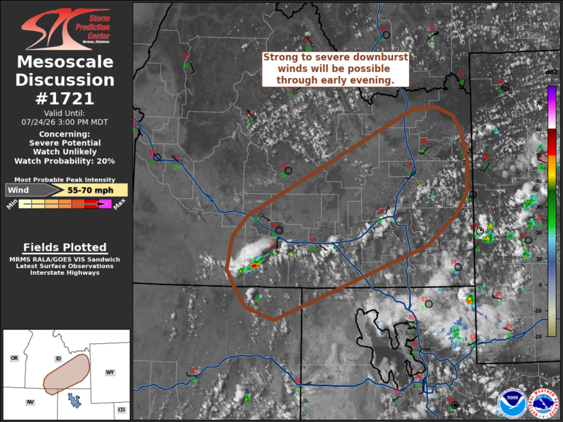
   Areas affected...Southeast Idaho and portions of far northeast
   Nevada and northwest Utah

   Concerning...Severe potential...Watch unlikely

   Valid 241902Z - 242100Z

   Probability of Watch Issuance...20 percent

   SUMMARY...Isolated thunderstorms capable of producing strong to
   severe downburst winds will spread across southeast Idaho through
   early evening. This threat will remain sufficiently limited to
   preclude watch issuance.

   DISCUSSION...Latest GOES imagery and lightning data show steady
   vertical growth of cumulus and the early stages of convective
   initiation across far northeast NV, northwest UT, and south-central
   ID. Continued development is expected through mid-afternoon as
   daytime heating and orographic ascent strengthens and any lingering
   inhibition is eroded. Immediately downstream from this activity,
   temperatures are warming into the mid 90s and low 100s with
   dewpoints mixing into the upper 40s and low 50s. Although RAP
   mesoanalyses suggests MLCAPE has only increased to around 500 J/kg,
   modifying a recent 18 UTC LKN based on downstream observations
   suggests MLCAPE has actually increased to around 1000 J/kg.
   Consequently, a few robust thunderstorms will likely emerge in the
   coming hours.

   The potential for strong/severe downburst winds should increase as
   this activity spreads into the hotter, more deeply mixed environment
   air mass within the Snake River Plain - largely driven by the
   propensity for downdraft accelerations through a ~3 km deep boundary
   layer. This scenario is reflected in recent HRRR/RRFS solutions,
   which depict the potential for downbursts winds on the order of
   55-70 mph. Despite this potential, modest deep-layer wind shear
   (sampled by the 18 UTC LKN sounding) suggests that storm modes will
   most likely remain poorly organized and transient, which limits
   confidence on the overall coverage/duration of the severe threat and
   the need for watch issuance.

   ..Moore/Smith.. 07/24/2026

   ...Please see www.spc.noaa.gov for graphic product...

   ATTN...WFO...SLC...PIH...BOI...LKN...

   LAT...LON   41731501 42011522 42221534 42641526 42911499 44281208
               44311167 44211138 44011124 43611113 43191115 42921135
               42521186 41561452 41731501

   MOST PROBABLE PEAK WIND GUST...55-70 MPH
|
|
|
Top/All Mesoscale Discussions/Forecast Products/Home |
|
Source link