

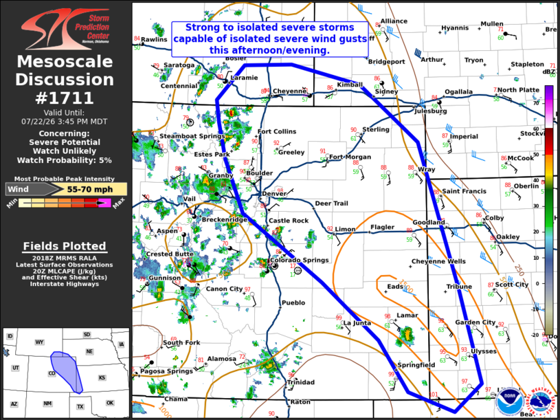
| Mesoscale Discussion 1711 | |
| < Previous MD | |

|
|
   Mesoscale Discussion 1711
   NWS Storm Prediction Center Norman OK
   0319 PM CDT Wed Jul 22 2026

   Areas affected...northeast Colorado and vicinity to far southwest
   Kansas and southeast Colorado

   Concerning...Severe potential...Watch unlikely

   Valid 222019Z - 222145Z

   Probability of Watch Issuance...5 percent

   SUMMARY...Strong to isolated severe storms capable of isolated
   severe wind gusts are possible this afternoon and evening.

   DISCUSSION...Storms have started to develop within a well-mixed
   airmass along a stalled front from southeast Colorado and arcing
   back to the Front Range near the Denver metro area. The two most
   likely corridors for storms at this time are across southeast
   Colorado where clusters of cumulus have developed with temperatures
   near 100F and off of the terrain in north-central Colorado.
   Temperatures in the 90s with dewpoints in the 50s (yielding 500-1000
   J/kg MLCAPE) and 25 to 30 knots of mid-level shear will support some
   organized multicells capable of isolated severe wind gusts. The
   marginal shear and instability will limit a greater threat.
   Therefore, no watch is anticipated.

   ..Bentley/Thompson.. 07/22/2026

   ...Please see www.spc.noaa.gov for graphic product...

   ATTN...WFO...DDC...GLD...AMA...PUB...BOU...CYS...

   LAT...LON   40510219 38490151 37200115 36810162 37090240 37810290
               38590389 39530529 40250562 40750575 41070579 41540531
               41560446 41290322 40510219

   MOST PROBABLE PEAK WIND GUST...55-70 MPH
|
|
|
Top/All Mesoscale Discussions/Forecast Products/Home |
|
Source link