

| Mesoscale Discussion 1680 | |
| < Previous MD | |

|
|
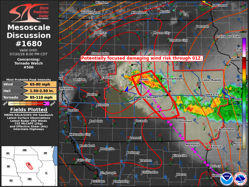
Mesoscale Discussion 1680 NWS Storm Prediction Center Norman OK 0635 PM CDT Mon Jul 20 2026 Areas affected...central Iowa Concerning...Tornado Watch 500... Valid 202335Z - 210100Z The severe weather threat for Tornado Watch 500 continues. SUMMARY...A focused corridor of damaging wind potential may be evolving near or just east of the Des Moines vicinity through 01Z. Large to very large hail is also possible. DISCUSSION...Latest trends in volumetric radar data indicate multiple supercells near Ames with some signal that a larger-than-RFD-scale cold pool may be evolving. An outflow boundary precedes those storms with that feature moving southwest at around 10 kt. Current thinking is that continued storm mergers may support the evolution of another bow echo configuration, which would track to the south-southeast along the immediate cool side of the leading outflow boundary, near or just to the east of the Des Moines metro area. Should that scenario unfold, corridor of strong winds with gusts of 65-75 mph are possible. To the immediate west/northwest, additional supercell structures may continue to backbuild, near the intersection of the east-west front and north-south outflow boundary. Large to very large hail will remain possible in that regime, as well as the potential for a tornado or two. ..Mead.. 07/20/2026 ...Please see www.spc.noaa.gov for graphic product... ATTN...WFO...DVN...DMX... LAT...LON 41369318 41769365 42159386 42299323 41539249 41229236 41149263 41129287 41369318 MOST PROBABLE PEAK TORNADO INTENSITY...85-110 MPH MOST PROBABLE PEAK WIND GUST...65-80 MPH MOST PROBABLE PEAK HAIL SIZE...1.50-2.50 IN |
|
|
Top/All Mesoscale Discussions/Forecast Products/Home |
|
Source link