

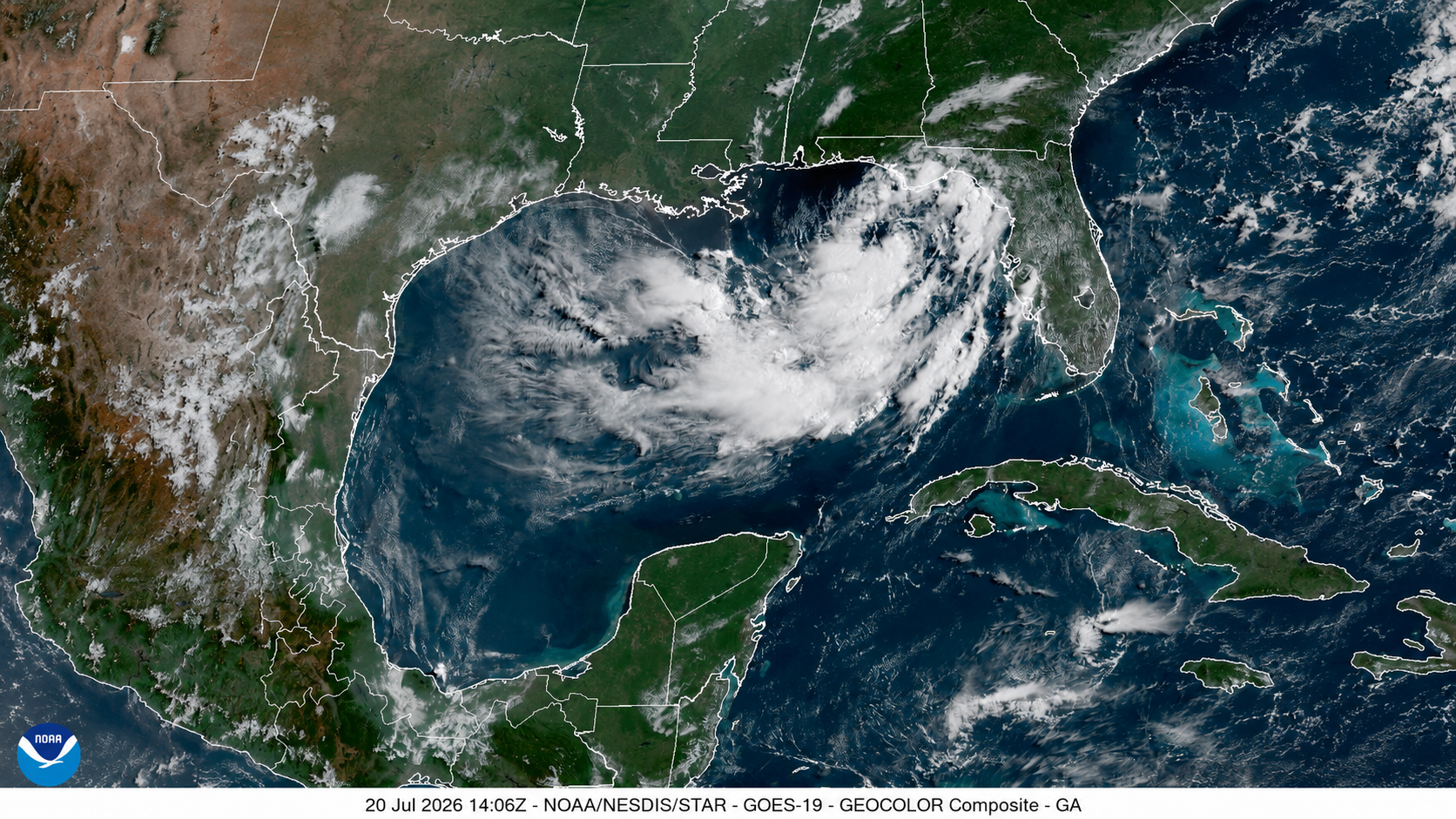
After what seemed like rapid development from Tropical Depression Two, the system has slowed in organization over the last 24 hours. Much of its lack of organization is due to dry air intruding into the system from the northeast, which prevented it from becoming better organized overnight Sunday. Wind shear also appears to be increasing and is expected to remain strong, around 25 knots, through Tuesday, which will keep this system from intensifying quickly while it crawls over the northeastern Gulf.
Weather pattern keeping TD 2 crawling
The high-pressure system centered over the central United States will continue to steer the storm, which will get the name Bertha if it intensifies to tropical storm status, primarily westward this week. Another area of high pressure over the western Atlantic is preventing the tropical system from being pulled northward by the trough currently digging across the eastern United States. As these two high-pressure systems sandwich the tropical depression, the storm has very little steering flow. Over the weekend, TD 2 became nearly stationary, and as of Monday morning, it was moving northwest at only about 3 mph (6 km/h). This slow movement is expected to continue through at least late Tuesday afternoon. Once TD 2 begins to accelerate, we expect it to make a more pronounced westward turn.

The National Hurricane Center‘s cone of uncertainty remains quite broad, with the forecast center ranging from a landfall near the southeastern Louisiana coast on Wednesday afternoon to a track that keeps it about 100 miles south of the coastline. If the center takes the southern track and remains over water, it could mean a bit more strengthening as waters are plenty warm between 85 and 87 degrees F (29 to 30 degrees C).
This will be an all-week system
The latest official forecast from the National Hurricane Center brings future Tropical Storm Bertha ashore over the marshes of eastern Plaquemines Parish before it slowly tracks across coastal Louisiana on Wednesday and Thursday. The system could then re-emerge over the far northwestern Gulf of Mexico, where it may make a second landfall as a tropical depression somewhere along the southeast Texas coast by late this week or early next weekend.
Tropical Storm Watches remain in effect from the Florida Panhandle westward to Plaquemines Parish in Louisiana. These will likely be upgraded to Tropical Storm Warnings later today or on Tuesday. There is also a Storm Surge Watch in effect from the Alabama/Florida Border to the Mouth of the Mississippi River, Louisiana. Winds are expected to begin increasing Monday night and continue through Tuesday across the watch area. Keep in mind that TD 2 will likely expand its wind field as it moves slowly. Storms that struggle with dry-air intrusion often compensate by becoming larger. Also remember that although moving slowly, the system will continue to gain latitude over the next day or two. As a result, persistent onshore winds will continue to produce hazardous surf and rough marine conditions along Florida’s west coast through the middle of the week.

The system’s west-northwest motion will also keep onshore winds blowing from the Florida Panhandle through the central Gulf Coast for much of the week. As a result, storm surge combined with several cycles of high tide will likely produce coastal flooding as water is pushed inland. Areas from the Florida Panhandle through the central Gulf Coast, including Mobile Bay, could experience up to 3 feet of storm surge.
The storm’s slow movement will also lead to prolonged periods of heavy rainfall across the Gulf Coast states. Rainfall totals could easily exceed 6 inches in isolated locations throughout the week.
TD 2 will bring drought-easing rains to Louisiana and the Florida Panhandle
The National Hurricane Center is forecasting the second tropical system of the season to bring rains of 6 inches for portions of southern Louisiana and the Florida Panhandle. While rains of this magnitude could well cause damaging flooding, they will also be beneficial: the Gulf Coast has been suffering from long-term drought, and a significant deluge is required to break it. In southern Louisiana, NOAA’s latest Drought Termination and Amelioration map (Fig. 3) shows that southern Louisiana needs 7-11 inches of rain in just one month to bring it out of long-term drought; the Florida panhandle needs about 14 inches. The place that REALLY needs the rain is the Florida peninsula, where 22-25 inches of rain is needed in one month to break its long-term drought. Unfortunately, rains are predicted to miss the Florida peninsula; less than an inch of rain is currently forecast for it over the next seven days.

Florida has received rain from the tropical system’s rainbands, but it is not enough to dent the deficit. Across west-central Florida, as highlighted by Bob Henson during his weekend coverage of Tropical Depression Two, rainfall totals ranged from 1 to 3 inches in Sarasota and Venice, while three-day totals just west of St. Petersburg reached between 6 and 7 inches.
As future Bertha slowly moves away, rain bands will gradually diminish across the Florida Peninsula. However, heavier clusters of rain are expected to spread into the Florida Panhandle, along the Alabama and Mississippi coasts, and into southern Louisiana.
Is it unusual for a storm to move westward across the Gulf?
As long as the atmospheric pattern supports it, tropical cyclones can move in directions that may seem unusual. For a westward motion like this to occur (as opposed to the more common northwestward paths), there is typically a strong subtropical ridge positioned north of the storm. This ridge blocks the cyclone from making its natural turn northward while steering currents remain weak, forcing the system farther west.
Once it gets named, Tropical Storm Bertha will join a relatively short list of storms that have formed over the eastern Gulf of Mexico and moved westward. Tropical Storm Fernand in 2019 was one of the most recent examples. Although it did not actually form in the eastern Gulf, it followed a similar westward track before making landfall in northeastern Mexico on September 4, 2019.
An even more comparable track was Hurricane Erika in 2003, which crossed much of the Gulf from east to west. Erika formed on August 14 from the remnants of a frontal boundary, strengthened into a hurricane on August 15, and made landfall near Tamaulipas, Mexico, on August 16 as a Category 1 hurricane with maximum sustained winds of 75 mph (120 km/h).
Jeff Masters and Bob Henson contributed to this post.

Source link