

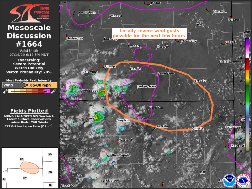
| Mesoscale Discussion 1664 | |
| < Previous MD | |

|
|
   Mesoscale Discussion 1664
   NWS Storm Prediction Center Norman OK
   0442 PM CDT Sun Jul 19 2026

   Areas affected...Parts of south-central and southeast MT into
   north-central and northeast WY

   Concerning...Severe potential...Watch unlikely

   Valid 192142Z - 200015Z

   Probability of Watch Issuance...20 percent

   SUMMARY...A few locally severe wind gusts will be possible with
   high-based thunderstorms over the next few hours (through around
   01Z). The localized nature of the threat should preclude the need
   for a watch.

   DISCUSSION...Potentially aided by a passing midlevel westerly jet
   steak across northern/central MT (well sampled by the BLX VWP),
   isolated high-based thunderstorms are evolving over the higher
   terrain of north-central WY into south-central MT this afternoon.
   Despite the presence of weak buoyancy, these storms will be moving
   through an area of steep low/midlevel lapse rates (around 50 deg
   T/Td spreads). This, combined with a long/straight hodograph (around
   30-40 kt of effective shear), will support a couple loosely
   organized clusters capable of producing severe wind gusts through
   around 01Z. If a more-organized cold pool can evolve, isolated
   significant gusts upwards of 75 mph cannot be ruled out. The
   severe-wind risk is expected to remain too localized for a watch.

   ..Weinman/Hart.. 07/19/2026

   ...Please see www.spc.noaa.gov for graphic product...

   ATTN...WFO...UNR...BYZ...RIW...

   LAT...LON   44290627 44580761 44930832 45460847 45780829 45940791
               45950743 45870653 45640560 45200491 44910477 44550484
               44330538 44290627

   MOST PROBABLE PEAK WIND GUST...65-80 MPH
|
|
|
Top/All Mesoscale Discussions/Forecast Products/Home |
|
Source link