

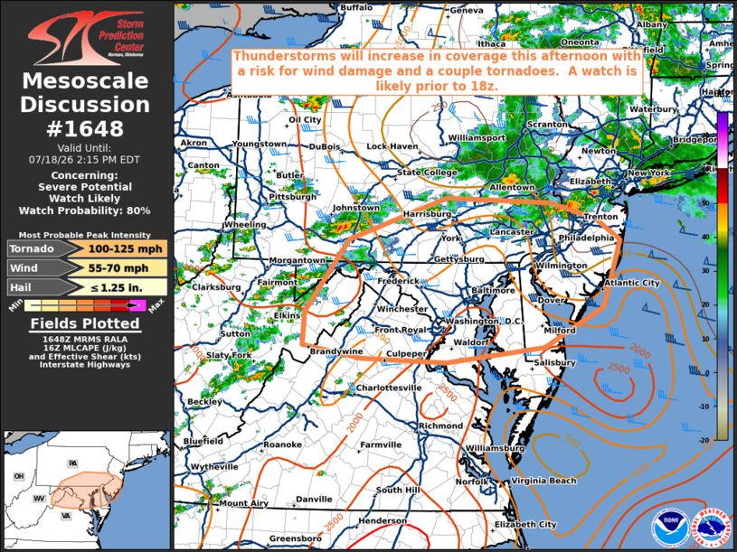
| Mesoscale Discussion 1648 | |
| < Previous MD | |

|
|
   Mesoscale Discussion 1648
   NWS Storm Prediction Center Norman OK
   1150 AM CDT Sat Jul 18 2026

   Areas affected...portions of southern Pennsylvania...eastern West
   Virginia...northern Virginia...much of
   Maryland...Delaware...southern New Jersey

   Concerning...Severe potential...Watch likely

   Valid 181650Z - 181815Z

   Probability of Watch Issuance...80 percent

   SUMMARY...Thunderstorms are expected to increase in coverage and
   intensity through early-mid afternoon. Damaging winds will be the
   primary concern as storms evolve into eastward-moving clusters and
   line segments.  A watch is likely prior to 18z.

   DISCUSSION...Strong boundary-layer heating of a very moist air mass
   is ongoing across the discussion area as of 1645z, contributing to
   moderate/pockets of strong surface-based instability. Thunderstorms
   will continue to increase in coverage across the higher terrain, and
   along a north-south confluence zone across southern PA south into
   northern VA, during the next few hours. As coverage continues to
   increase and low-level lapse rates steepen, the potential for
   damaging gusts will increase across the discussion area this
   afternoon and early evening. Additionally, low-level shear will
   remain locally enhanced in the vicinity of a warm front across
   southeast PA/southern NJ. Deep-layer shear will be supportive of
   supercell structures, and the risk for tornadoes, potentially
   strong, will be maximized in this area.

   Convective trends will continue to be monitored, and a watch is
   likely prior to 18z.

   ..Bunting/Thompson.. 07/18/2026

   ...Please see www.spc.noaa.gov for graphic product...

   ATTN...WFO...PHI...AKQ...CTP...LWX...PBZ...

   LAT...LON   39077931 40007859 40547698 40477526 40267451 39987411
               39137439 38627538 38437699 38487839 38647934 39077931

   MOST PROBABLE PEAK TORNADO INTENSITY...100-125 MPH
   MOST PROBABLE PEAK WIND GUST...55-70 MPH
   MOST PROBABLE PEAK HAIL SIZE...UP TO 1.25 IN
|
|
|
Top/All Mesoscale Discussions/Forecast Products/Home |
|
Source link